Filter: Categories of Wisconsin Historical Images
Filter: Subject of Land
Filter: County of Sawyer
Filter: Categories of Wisconsin Historical Images
Filter: Subject of Land
Filter: County of Sawyer
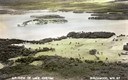
| Date: | 1955 |
|---|---|
| Description: | Aerial view of Treeland Pines resort on Lake Chippewa. Caption reads: "Air View of Bob Cammack's Treeland Pines Resort; Lake Chippewa, Hayward, Wis." |
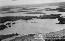
| Date: | 1955 |
|---|---|
| Description: | Aerial view of Treeland Pines Resort on Lake Chippewa. Caption reads: "Aerial View of Treeland Pines Resort on Lake Chippewa (The Flowage), Hayward, Wis." |
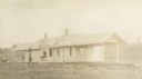
| Date: | 1910 |
|---|---|
| Description: | Exterior view of railroad tracks in front of the station. |
| Date: | |
|---|---|
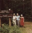
| Description: | Marker at the Uhrenholdt Memorial Forest established by farmer Soren J. Uhrenholdt on land that was part of northern Wisconsin's "Cutover Region." A leader... |
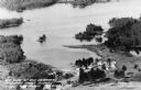
| Date: | 1935 |
|---|---|
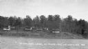
| Description: | View from lake of numerous cottages and outhouses on hillside near Round Lake. |

| Date: | 1935 |
|---|---|
| Description: | Log steps leading up steep incline to a log cabin with a stone chimney. |

| Date: | 1935 |
|---|---|
| Description: | Aerial view of Alex LeTourneau's Resort on Spider Lake. |

| Date: | 1909 |
|---|---|
| Description: | Map of Sawyer County with an advertisement for land sales through Fuley & Quail of Hayward, Wisconsin. There is a small inset map of railroads accessible i... |
| Date: | 1935 |
|---|---|
| Description: | Small shack on shore of Little Spider Lake. Sign over door reads: "The Compleat Angler." There is a shelter made of birch tree trunks that has a birdhouse ... |
| Date: | 1935 |
|---|---|
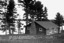
| Description: | Single-story log cabin with stone fireplace chimney on shore of Spider Lake. |
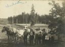
| Date: | 1910 |
|---|---|
| Description: | Uhrenholdt family on the family farm in Seeley. |
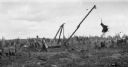
| Date: | |
|---|---|
| Description: | A group of men remove a large stump with the help of horses and a winch on the family farm. |

| Date: | 1923 |
|---|---|
| Description: | This map from the Wisconsin Lakes and Parks Association shows the area of a proposed state park, much of which is now part of the Flambeau River State Fore... |

| Date: | 1933 |
|---|---|
| Description: | View of a large rock that says "Boulder Lodge." Behind the boulder are the cottages at Boulder Lodge. |
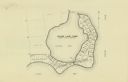
| Date: | |
|---|---|
| Description: | This map shows the lots surrounding Hinton Bay on Round Lake in the Town of Hayward, Sawyer County, Wisconsin. |

| Date: | 1920 |
|---|---|
| Description: | This map of Sawyer County, Wisconsin, from the early 20th century shows the township and range system, towns, sections, cities and villages, railroads, hig... |

| Date: | 1897 |
|---|---|
| Description: | This 1897 map of Sawyer County, Wisconsin, shows the township and range system, sections, roads, farm houses, camps, school houses, dams, bridges, Indian r... |

| Date: | 1900 |
|---|---|
| Description: | This map of Sawyer County, Wisconsin, shows the numbered "sub-school-districts of the town of Hayward" school houses, and the Indian reservation. The towns... |

| Date: | 1902 |
|---|---|
| Description: | This 1902 map of the eastern portion of Sawyer County, Wisconsin, shows the township and range system, sections, roads, farm houses, camps, school houses, ... |
If you didn't find the material you searched for, our Library Reference Staff can help.
Call our reference desk at 608-264-6535 or email us at: