 Filter: Categories of Wisconsin Historical Images
Filter: Subject of Land
Filter: County of Rock
Filter: Categories of Wisconsin Historical Images
Filter: Subject of Land
Filter: County of Rock

| Date: | 1877 |
|---|---|
| Description: | Bird's-eye map of Janesville on the Rock River. |
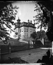
| Date: | 1875 |
|---|---|
| Description: | View across wooden platform of a brick high school on a hill surrounded by a fence. The school has a mansard roof and what appears to be a bell tower above... |
| Date: | 1910 |
|---|---|
| Description: | View of Emerson Hall, with trees and a lawn in the foreground. |

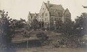
| Date: | 1920 |
|---|---|
| Description: | Elevated view of the old High School building. Caption reads: "Bird's-Eye View, from Old high School Building, Janesville, Wis." |
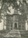
| Date: | 1893 |
|---|---|
| Description: | View from the south, with a railroad in the foreground, a river in the middle distance, and Janesville in the background. |
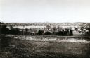
| Date: | 1915 |
|---|---|
| Description: | Main Hall at Milton College. Stamp on print reads: "W. P. Clarke, Pharmacy, Milton, Wis." |
| Date: | 05 1980 |
|---|---|
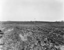
| Description: | View over plowed field, with a telephone pole in the middle distance. Farm buildings are on the hill in the background. |

| Date: | |
|---|---|
| Description: | A mobile home sits alone at the edge of an empty field adjacent to a septic tank and telephone pole. |
| Date: | |
|---|---|
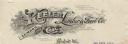
| Description: | Memohead of Keeler Lumber & Fuel Company of Beloit, Wisconsin, a dealer in lumber and coal, with a tree stump, a pile of smoldering coal, and wisps of smok... |

| Date: | 1920 |
|---|---|
| Description: | Two cottages at Burgy Mounds on Lake Koshkonong. |

| Date: | 1920 |
|---|---|
| Description: | View from shore of a group of men posing on a dock at Burgy Mounds on Lake Koshkonong. Boats are tied to the dock. There are a number of people in boats fa... |
| Date: | |
|---|---|
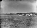
| Description: | Fields, cattle in a pasture, and farm buildings in the countryside, possibly near Avon, Wisconsin. |
| Date: | 1912 |
|---|---|
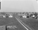
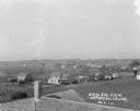
| Description: | Elevated view of town with farm fields in the foreground, and low, rolling hills in the background. There is a church steeple in the far background on the ... |
| Date: | 1912 |
|---|---|
| Description: | Elevated view over rooftops. Farm fields and houses are in the background. |

| Date: | 1853 |
|---|---|
| Description: | Map covers area between the cities of Janesville and Kenosha in Rock, Walworth, and Kenosha counties for railroad routes. Lakes and counties are labelled. ... |

| Date: | 09 21 1931 |
|---|---|
| Description: | Destroyed farm building next to a standing barn. Agricultural equipment is in the foreground. |

| Date: | 1800 |
|---|---|
| Description: | This map on two sheets shows a group of ancient mounds near the southeast corner of the city of Beloit and a group of ancient mounds north of Rockton Stati... |

| Date: | 1973 |
|---|---|
| Description: | This map is a photocopy of the original plat of Beloit from 1838. The map shows labeled roads, lots, and rivers. |
| Date: | 1887 |
|---|---|
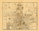
| Description: | This map of Beloit shows labeled wards, plat of town, roads, railroads, the Rock River, city boundaries, and land ownership by name. The back of the map is... |
If you didn't find the material you searched for, our Library Reference Staff can help.
Call our reference desk at 608-264-6535 or email us at:
