 Filter: Categories of Wisconsin Historical Images
Filter: Subject of Land
Filter: County of Grant
Filter: Categories of Wisconsin Historical Images
Filter: Subject of Land
Filter: County of Grant

| Date: | 1938 |
|---|---|
| Description: | Elevated view of the Wisconsin River from Bogus Bluff. There is a tree in the foreground and sandbars in the river. |
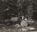
| Date: | 1920 |
|---|---|
| Description: | View towards hillside with an outcropping of large talus rocks surrounded by trees near Castle Rock village. In the foreground is what appears to be a dirt... |

| Date: | 1850 |
|---|---|
| Description: | This map of Cassville shows plat of town, roads, and the Mississippi River. Relief is shown by hachures. The map includes an inset map of a Plat of townshi... |

| Date: | 1850 |
|---|---|
| Description: | This map of Cassville shows plat of the town, roads, landings and public wharfs and the Mississippi River. |

| Date: | 1936 |
|---|---|
| Description: | Four men are building the wall at Signal Point Lookout in Wyalusing State Park. They are part of Works Progress Administration (WPA) Project #8656-8. Th... |
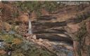
| Date: | 1914 |
|---|---|
| Description: | Postcard for Marquette Park in Grant County, number 4706 in a series by E.A. Bishop of Racine. The caption on the back of the postcard reads: "The pictures... |

| Date: | 1960 |
|---|---|
| Description: | This street map was likely given out by Mound City Bank and features a legend of points of interest and a street index. Streets are labeled as is the Round... |
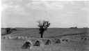
| Date: | 1936 |
|---|---|
| Description: | Shocks of oats form long rows in a large, rolling field. A single tree is standing in the field. On the reverse of the print is written: "Greenfield near L... |

| Date: | 1906 |
|---|---|
| Description: | This topographical map shows the Little Platte River, shafts, test-pits, old workings, contour lines of Galena limestone elevation, railroads, and building... |

| Date: | 06 1845 |
|---|---|
| Description: | This map is pen-and-ink on paper and shows the numbers, dimensions, and acreages of lots, as well as survey monuments and streets. Also included is a certi... |
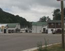
| Date: | 07 27 2012 |
|---|---|
| Description: | A view down Main Street in Beetown on an overcast day. |
| Date: | 07 27 2012 |
|---|---|
| Description: | Exterior view of the public school, positioned on a small hill. |
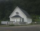
| Date: | 07 27 2012 |
|---|---|
| Description: | Exterior view of the Methodist Evangelical Church, with stairs and a ramp at the front of the building. |

| Date: | |
|---|---|
| Description: | A vintage view and a modern view down Main Street, presented as a pair. |

| Date: | |
|---|---|
| Description: | A vintage view and a modern view of the Public School, presented as a pair. |

| Date: | |
|---|---|
| Description: | A vintage view and a modern view of the Methodist Evangelical Church, presented as a pair. |
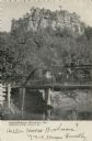
| Date: | 1906 |
|---|---|
| Description: | View of Castle Rock in the distance. In the foreground a woman is driving a horse-drawn carriage across a bridge. Caption reads: "Castle Rock near Fennimor... |
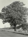
| Date: | 1955 |
|---|---|
| Description: | A very large white oak tree standing along County Trunk Highway S dwarfs a utility pole nearby. There is a barn across a field in the far background. The t... |
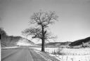
| Date: | 1982 |
|---|---|
| Description: | A large white oak in a snowy landscape along County Trunk Highway S. The tree is asymmetrical, missing portions of several major limbs. There is a silo an... |
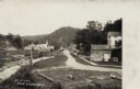
| Date: | 1908 |
|---|---|
| Description: | View of a street with a lumber office and a church on the left, and dwellings on the right. A man and a dog are on the sidewalk. A tree-covered hill is in ... |
If you didn't find the material you searched for, our Library Reference Staff can help.
Call our reference desk at 608-264-6535 or email us at: