Filter: Categories of Wisconsin Historical Images
Filter: Subject of Land
Filter: County of Dane
Filter: Categories of Wisconsin Historical Images
Filter: Subject of Land
Filter: County of Dane
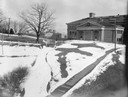
| Date: | 03 27 1928 |
|---|---|
| Description: | Winter scene with Agriculture Hall, covered with snow, on the University of Wisconsin-Madison campus. Agriculture Hall is in the distance. |
| Date: | 1861 |
|---|---|
| Description: | Soldiers in formation at Camp Randall during winter. The season [there appears to be snow on the ground] and the tents indicate that this image was made in... |

| Date: | 1908 |
|---|---|
| Description: | A panoramic aerial view of the Isthmus taken from a kite. Lake Mendota is to the right in the background with Picnic Point jutting into the lake. The photo... |

| Date: | 06 07 1954 |
|---|---|
| Description: | Aerial view of the Midvale neighborhood under construction showing the intersection of Midvale and Tokay Boulevards near the southwestern city limits of Ma... |

| Date: | 1930 |
|---|---|
| Description: | Elevated view of the west wing of the Wisconsin State Capitol building. A view of the fourth capitol with snow flocked trees and snow-covered lawn and side... |

| Date: | 1851 |
|---|---|
| Description: | Plat map of the Town of Madison (Township 7N, Range 9E), from Volume 4, Federal Survey Plat Books. |

| Date: | 1873 |
|---|---|
| Description: | Map of the township of Windsor, from the "Atlas of Dane County." |
| Date: | |
|---|---|
| Description: | A turtle effigy mound on the University of Wisconsin-Madison campus, outlined by melting snow. |

| Date: | 1861 |
|---|---|
| Description: | Drawn the first year of the Civil War, this colored 1861 map of Dane County shows its towns, cities and lakes. It includes insets of the wards of Madison a... |

| Date: | 05 20 1930 |
|---|---|
| Description: | The Montgomery Ward Store Building at 100 North Hamilton Street, at the intersection of Pinckney and North Hamilton Streets. The building was designed by L... |
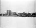
| Date: | 12 18 1955 |
|---|---|
| Description: | Downtown Madison lakeshore taken from Lake Monona in line with South Pinckney Street. Includes St. Raphael's steeple, 1 West Wilson Street state office bui... |

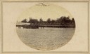
| Date: | 1876 |
|---|---|
| Description: | Bird's-eye view of Black Earth. |

| Date: | 05 09 1908 |
|---|---|
| Description: | Kite aerial panoramic photograph of the central business district. In the distance is Lake Mendota. The fire damaged Wisconsin State Capitol is in the cent... |
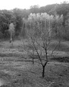
| Date: | 10 20 1963 |
|---|---|
| Description: | Bare tree, complemented by birches in bright fall foliage, in the vicinity of Highway J, south. |
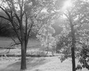
| Date: | 06 25 1964 |
|---|---|
| Description: | Trees in the valley against the sun, below Stewart Park. |

| Date: | 1839 |
|---|---|
| Description: | A map of the Wiskonsin [sic] and Neenah or Fox Rivers. |

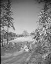
| Date: | 12 01 1962 |
|---|---|
| Description: | A farm road between fields in late sunlight, looking towards Mounds Creek in the vicinity of CTH F. |
If you didn't find the material you searched for, our Library Reference Staff can help.
Call our reference desk at 608-264-6535 or email us at: