 Filter: Categories of Wisconsin Historical Images
Filter: Subject of Land
Filter: County of Ashland
Filter: Categories of Wisconsin Historical Images
Filter: Subject of Land
Filter: County of Ashland
| Date: | 1937 |
|---|---|
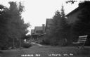
| Description: | Sidewalk in front of four houses along Nebraska Row at Madeline Island. Nebraska Row was started by Col. Frederick Woods in 1899 on the bluff at the wester... |
| Date: | 1937 |
|---|---|
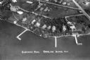
| Description: | Aerial view of Nebraska Row on the lakeshore of the west side of La Pointe, showing houses, roads and piers. Nebraska Row was started in 1899 when summer r... |
| Date: | 1937 |
|---|---|
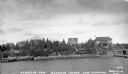
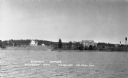
| Description: | View from lake of the summer homes on Nebraska Row along the shoreline of Lake Superior. |
| Date: | 1937 |
|---|---|
| Description: | Elevated view of a woman standing on lawn of the Woods mansion on Nebraska Row. Bayfield is visible on the opposite mainland shore of Lake Superior. |

| Date: | 1931 |
|---|---|
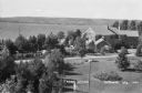
| Description: | View looking east on Grant Street in Glidden Wisconsin. |

| Date: | 1981 |
|---|---|
| Description: | Plat map of Madeline Island surrounded by Basswood, Michigan and Gull Islands. |

| Date: | 1934 |
|---|---|
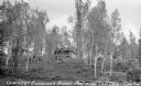
| Description: | View down hill of a tavern, with signs advertising "Budweiser" and "Beer," on the shores of Clam Lake. There are numerous outbuildings and two automobiles ... |

| Date: | |
|---|---|
| Description: | View of water streaming down the rock and tree-lined Tyler Falls. A white walk bridge is in the background. |

| Date: | 09 24 1910 |
|---|---|
| Description: | View of several fisherman's homes on Bear Island, one of the islands that make up the Apostle Islands. An American flag is flying between buildings and a d... |
| Date: | |
|---|---|
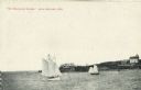
| Description: | View across water towards two schooners off the shore of Madeline Island, one of the islands that comprise the Apostle Islands in Lake Superior. Two large ... |
| Date: | 1935 |
|---|---|
| Description: | View from lake up hill of two wooden cabins. Nearby is an automobile, stairs to the beach, and some boats on the shoreline at Buehlow's Resort on Partridge... |
| Date: | 1937 |
|---|---|
| Description: | View from the lake of the summer homes on Nebraska Row along the shoreline of Lake Superior. The water tower and church steeple are visible on the far righ... |

| Date: | 1939 |
|---|---|
| Description: | This map shows the towns to Gingles, Sanborn, and Guney as well as Chequamegon Bay, Kakagon River, White River, Marengo River, Bad River, Potato River, Vau... |
| Date: | 1938 |
|---|---|
| Description: | Aerial view looking down over the lawn and wood shingle lakeshore home, Woods Manor, a part of Nebraska Row on Madeline Island. In the distance is Lake Sup... |
| Date: | 1938 |
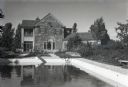
|---|---|
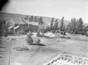
| Description: | View of the two-story, wood shingle, lake shore home, Woods Manor, a part of Nebraska Row on Madeline Island. In the foreground is a swimming pool surround... |

| Date: | 1938 |
|---|---|
| Description: | View of a house on Nebraska Row on Madeline Island. In the foreground is a flag pole, bench, path, lawn and trees. On the left are docks from the lake shor... |

| Date: | |
|---|---|
| Description: | Aerial view of town, showing the shoreline of Lake Superior, ore docks, roads, houses, buildings, trees, and smokestacks. Text describing this photograph s... |

| Date: | 1907 |
|---|---|
| Description: | A map of the eastern portion of the Apostle Islands group, and a detailed map of Gull Island showing the relief on the island, are included here, along wit... |
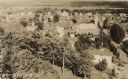
| Date: | 1932 |
|---|---|
| Description: | Aerial view of town looking down from hill lined with trees. In the foreground railroad tracks cross a road. A church building and numerous dwellings are a... |

| Date: | 1834 |
|---|---|
| Description: | This copy of an 1834 map in the American Fur Company's papers held by the New-York Historical Society shows an outline of Chequamegon Bay and Madeline Isla... |
If you didn't find the material you searched for, our Library Reference Staff can help.
Call our reference desk at 608-264-6535 or email us at: