 Filter: Categories of Wisconsin Historical Images
Filter: Subject of Land
Filter: Community of Sheboygan
Filter: Categories of Wisconsin Historical Images
Filter: Subject of Land
Filter: Community of Sheboygan

| Date: | 1885 |
|---|---|
| Description: | Bird's-eye view of Sheboygan, with inset of J.J. Volrath Manufacturing Company. |

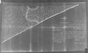
| Date: | 1840 |
|---|---|
| Description: | This is a plat map of Sheboygan showing the Sheboygan River and Lake Michigan. Streets are labeled and plats are numbered in quadrants. Some points of inte... |
| Date: | 1900 |
|---|---|
| Description: | This map shows the paper city situated at the mouth of the Memee (Pigeon) River in Sheboygan County, just north of Sheboygan. Land parcels, streets, and ri... |

| Date: | 04 1938 |
|---|---|
| Description: | Elevated view from shoreline towards a boy using a single paddle to propel a small rowboat on the Sheboygan River. There are five rigs set up along the sho... |

| Date: | 1910 |
|---|---|
| Description: | Text on front reads: "Schreiers Brewery, Sheboygan, Wis." The brewery was founded in 1856 by Konrad Schreier. A fire completely destroyed the original brew... |
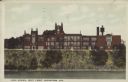
| Date: | 09 08 1923 |
|---|---|
| Description: | Text on front reads: "High School, West Front, Sheboygan, Wis." The school was named Sheboygan High School from 1922-1938, then Sheboygan Central High Scho... |

| Date: | 07 18 1938 |
|---|---|
| Description: | Text on front reads: "Vollrath Bowl, Sheboygan, Wis." The land was donated in 1917 by the Vollrath heirs and the construction of the Vollrath Park Zoo was ... |

| Date: | 1916 |
|---|---|
| Description: | Text on front reads: "North Point — Sheboygan, Wis." Elevated view of a Niagara limestone shelf of rock that rises above Lake Michigan. This rarely occurs ... |
If you didn't find the material you searched for, our Library Reference Staff can help.
Call our reference desk at 608-264-6535 or email us at: