 Filter: Categories of Wisconsin Historical Images
Filter: Subject of Lakes
Filter: Year of 1800-1899
Filter: Categories of Wisconsin Historical Images
Filter: Subject of Lakes
Filter: Year of 1800-1899

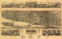
| Date: | 1868 |
|---|---|
| Description: | Bird's-eye map of Portage, with insets of the Court House and the Public School. |

| Date: | 1885 |
|---|---|
| Description: | Bird's-eye view of Sheboygan, with inset of J.J. Volrath Manufacturing Company. |

| Date: | 1882 |
|---|---|
| Description: | Bird's-eye map of Lake Geneva, looking southwest, with insets of points of interest. |
| Date: | 1883 |
|---|---|
| Description: | Bird's-eye map of Racine looking south west, with insets of points of interest. |

| Date: | 1867 |
|---|---|
| Description: | Bird's-eye map of Ripon, with insets of points of interest. |

| Date: | 1890 |
|---|---|
| Description: | Bird's-eye view of Superior, Wisconsin. |

| Date: | 1892 |
|---|---|
| Description: | Color bird's-eye map of Wauwatosa, looking east toward Milwaukee and Lake Michigan. Predominantly green with cream colored roadways, with six land plots ow... |
| Date: | 1885 |
|---|---|
| Description: | Bird's-eye map of Whitewater with insets of points of interest. |

| Date: | 1891 |
|---|---|
| Description: | Bird's-eye view of Eau Claire. |

| Date: | 1879 |
|---|---|
| Description: | Bird's-eye map of Lake Mills. |

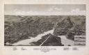
| Date: | 1870 |
|---|---|
| Description: | Bird's-eye map of Madison. The Lakeside House resort is in the foreground, which burned in 1877, in what is now Olin Park. |

| Date: | 1868 |
|---|---|
| Description: | Bird's-eye map of Manitowoc, with four insets. Manitowoc County. |

| Date: | 1898 |
|---|---|
| Description: | Bird's-eye map, looking west from shoreline on Lake Michigan of Milwaukee to Golden Lake in Waukesha County, with Kenosha and Fox Point at bottom corners, ... |

| Date: | 1870 |
|---|---|
| Description: | Birds-eye drawing of Oconomowoc depicts street names and street layouts, houses, trees, Oconomowoc River, Fowler Lake, and La Belle Lake. A reference key a... |

| Date: | 1893 |
|---|---|
| Description: | Bird's-eye map of Superior. Looking from the point, with Superior Bay on left, St. Louis Bay on right, below St. Louis River. |

| Date: | 1870 |
|---|---|
| Description: | Bird's-eye view of Whitewater, with insets. |
If you didn't find the material you searched for, our Library Reference Staff can help.
Call our reference desk at 608-264-6535 or email us at:


