 Filter: Categories of Wisconsin Historical Images
Filter: Subject of Lakes
Filter: Year of 1800-1899
Filter: Year of 1870-1879
Filter: Categories of Wisconsin Historical Images
Filter: Subject of Lakes
Filter: Year of 1800-1899
Filter: Year of 1870-1879
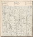
| Date: | 1873 |
|---|---|
| Description: | A map of Verona Township from the Dane County Atlas. |

| Date: | 1877 |
|---|---|
| Description: | Map of northern Wisconsin showing the lands owned by Cornell University (shaded portions) in 1877. The map depicts the lakes, river systems, towns, and th... |

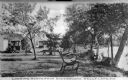
| Date: | 1870 |
|---|---|
| Description: | View of two lakeside cottage, which have docks and porches that overlook the lake. Caption reads: "Birch Walk, Kelly Lake, Wis." |
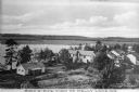
| Date: | 1870 |
|---|---|
| Description: | Elevated view of cottages along Kelly Lake's shoreline. Some of the buildings are two-story structures. Trees stand between the cottages and line the lake'... |
| Date: | 1870 |
|---|---|
| Description: | View toward three cottages along the tree-lined shore of Kelly Lake at Underwood Point. Small docks with boats are along the shoreline. A wooden bench with... |
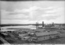
| Date: | 1872 |
|---|---|
| Description: | Elevated view of the Rice Lake Lumber Company Mill, taken from a high vantage point. A formation of logs is in the river, and piles of finished boards are ... |

| Date: | 1870 |
|---|---|
| Description: | Stereograph of a lake scene in Madison, probably looking south on Lake Monona at a boat race in progress. From the series "The Beauties of the City of Madi... |

| Date: | 1874 |
|---|---|
| Description: | A yellow mount stereograph of the railroad tracks skirting the edge of Devil's Lake, with several boats tied up alongside. From the stereograph series "The... |

| Date: | 1870 |
|---|---|
| Description: | Stereograph looking south from the post office at the corner of Mifflin Street and Wisconsin Avenue across one corner of the Capitol Square toward Grace Ep... |
| Date: | 1870 |
|---|---|
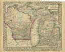
| Description: | A hand-colored map of Wisconsin and Michigan detailing the states’ rivers, lakes, counties, town and cities. The map gives the greatest length, breadth, me... |

| Date: | 1870 |
|---|---|
| Description: | A geological survey map of Wisconsin, with hand-colored portions showing the surveys completed from 1873 to 1875. Although the title and legend are in Wel... |

| Date: | 1870 |
|---|---|
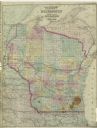
| Description: | Map of Wisconsin showing counties and their county seats, towns and cities with over 3,000 inhabitants, the Detroit and Milwaukee Steam Ship Line, and both... |

| Date: | 1871 |
|---|---|
| Description: | Map of Wisconsin and portions of Minnesota, Michigan, Illinois and Iowa show the major railway tracks and their connections in red and blue ink. Lakes, riv... |

| Date: | 1871 |
|---|---|
| Description: | A map of Wisconsin which shows the counties, county seats, those cities with over 3,000 inhabitants. The map also depicts the rivers, lakes, completed and ... |

| Date: | 1872 |
|---|---|
| Description: | A series of four hand-colored, geological maps of Wisconsin. Starting from the top of the page, the first map is of a section along the line of the 4th pri... |

| Date: | 1872 |
|---|---|
| Description: | A map of Wisconsin which shows the counties, county seats, those cities with over 3,000 inhabitants. The map also displays the rivers, lakes, completed and... |
| Date: | 1873 |
|---|---|
| Description: | A map of Wisconsin along with southeastern Minnesota and Iowa, northern Illinois and the Upper Peninsula of Michigan, showing the counties, county seats, v... |

| Date: | 1873 |
|---|---|
| Description: | A hand-colored map of Minnesota, Wisconsin, and Michigan shows the counties, cities, villages, rivers, lakes, railroads, and steamboat routes in these stat... |

| Date: | 1873 |
|---|---|
| Description: | Map of Wisconsin showing counties, county seats, cities with populations over 3,000, and congressional districts. The map also includes rivers, lakes, rail... |
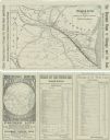
| Date: | 1874 |
|---|---|
| Description: | A folded brochure with a map of the Chicago to Saint Paul rail line through Wisconsin by way of the Chicago & North-Western and West Wisconsin Railways. Th... |
If you didn't find the material you searched for, our Library Reference Staff can help.
Call our reference desk at 608-264-6535 or email us at: