 Filter: Categories of Wisconsin Historical Images
Filter: Subject of Lakes
Filter: Year of 1800-1899
Filter: Year of 1860-1869
Filter: Creator Name of Unknown
Filter: Categories of Wisconsin Historical Images
Filter: Subject of Lakes
Filter: Year of 1800-1899
Filter: Year of 1860-1869
Filter: Creator Name of Unknown

| Date: | 1861 |
|---|---|
| Description: | Drawn the first year of the Civil War, this colored 1861 map of Dane County shows its towns, cities and lakes. It includes insets of the wards of Madison a... |

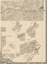
| Date: | 1868 |
|---|---|
| Description: | Bird's-eye map of Manitowoc, with four insets. Manitowoc County. |

| Date: | 1868 |
|---|---|
| Description: | Stereograph of an elevated view of the Vilas House hotel, East Main Street at Monona Avenue. |
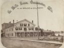
| Date: | 1867 |
|---|---|
| Description: | A summer resort, situated on the banks of Fowler and La Belle Lakes, in the village of Oconomowoc, thirty miles from Milwaukee on the St. Paul R.R. Men sta... |
| Date: | 1861 |
|---|---|
| Description: | Portion of a map showing Wisconsin villages including Cambria, Fall River, Columbus, Otsego, and Dekorra. |

| Date: | 1864 |
|---|---|
| Description: | A geological map of Wisconsin that shows the locations of different rock deposits such as limestone, sandstone, shale, plutonic and the Penokee Iron Range.... |

| Date: | 1868 |
|---|---|
| Description: | Wisconsin and parts of Michigan, Minnesota, Illinois and Iowa. It shows cities and towns, drainage, administrative boundaries and the railroad network with... |

| Date: | 1861 |
|---|---|
| Description: | This map shows railroad and other transportation routes in Wisconsin, northern Illinois, the Upper Peninsula of Michigan, portions of Iowa, Minnesota, and ... |

| Date: | 04 17 1866 |
|---|---|
| Description: | View across water towards the "Scutanawbequon," owned by Francis (Frank) Barnes, launched on April 17, 1866, with seven people aboard. "She was 50 feet lon... |

| Date: | 1868 |
|---|---|
| Description: | This map includes a table of estimated costs "by Brev. Maj. Gen. G.K. Warren Maj. U.S.E., of improvement of Wis. River from his survey of 1867." Included a... |
If you didn't find the material you searched for, our Library Reference Staff can help.
Call our reference desk at 608-264-6535 or email us at: