 Filter: Categories of Wisconsin Historical Images
Filter: Subject of Lakes
Filter: Year of 1800-1899
Filter: Year of 1850-1859
Filter: Categories of Wisconsin Historical Images
Filter: Subject of Lakes
Filter: Year of 1800-1899
Filter: Year of 1850-1859

| Date: | 1857 |
|---|---|
| Description: | This map depicts the township survey grid in Wisconsin, Michigan, northern Illinois, eastern Iowa, and southeastern Minnesota. Counties, named towns, citie... |

| Date: | 1857 |
|---|---|
| Description: | This map shows the township survey grid and identifies counties, named towns, cities and villages, rivers, lakes, and railroads. Boundaries are shown in bl... |

| Date: | 1858 |
|---|---|
| Description: | This map shows the township survey grid and identifies counties, named towns, cities and villages, rivers, lakes, and railroads and proposed railroads in W... |

| Date: | 1858 |
|---|---|
| Description: | This map of the entire state of Wisconsin depicts the township survey grid and identifies counties, named towns, cities and villages, rivers, lakes, railro... |

| Date: | 1859 |
|---|---|
| Description: | This map of the entire state of Wisconsin depicts the township survey grid and identifies counties, named towns, cities and villages, rivers, lakes, railro... |

| Date: | 1859 |
|---|---|
| Description: | This map, which includes eastern Iowa and northern Illinois but omits the northern and northwestern tiers of counties in Wisconsin, shows the township surv... |

| Date: | 1858 |
|---|---|
| Description: | An ink on paper map of Milwaukee County and the eastern portion of Waukesha County that shows the townships of Oak Creek, Franklin, Greenfield, Wauwatosa, ... |

| Date: | 1858 |
|---|---|
| Description: | This 1858 map of Racine County, Wisconsin, shows land ownership and acreages, the township and range grid, towns, cities and villages, roads, railroads, sc... |

| Date: | 1855 |
|---|---|
| Description: | This map by Increase Lapham shows the Penokee Iron Range in Ashland and Iron counties, Wisconsin. Part of the Gogebic Range, the Penokees extend from an ar... |

| Date: | 1859 |
|---|---|
| Description: | This 1859 map of Washington County, Wisconsin, shows the township and range grid, towns, sections, landownership and acreages, cities and villages, roads, ... |

| Date: | 1854 |
|---|---|
| Description: | This mid-19th century map of Dane County, Wisconsin, shows the township and range grid, towns, sections, cities, villages and post offices, lakes and strea... |

| Date: | 1855 |
|---|---|
| Description: | This 1855 map of Winnebago County, Wisconsin, shows the township and range grid, towns, cities, villages, and post offices, roads, and lakes and streams. |

| Date: | 1854 |
|---|---|
| Description: | Shows street grid, sections in adjacent townships, routes of railroads and projected railroads, post offices, and creeks. Table of references identifies ma... |

| Date: | 1859 |
|---|---|
| Description: | Shows townships and sections, landownership, roads, railroads, rural residences, schools, churches, and topography. Relief shown by hachures. "From governm... |

| Date: | 1858 |
|---|---|
| Description: | This 1858 map of Rock County, Wisconsin, shows the township and range grid, towns, sections, cities and villages, railroads, roads, property owners and res... |
| Date: | 1857 |
|---|---|
| Description: | Ink, pencil, and watercolor on paper. Register’s certificate in margin. On verso: Surveyor’s and Notary’s certificates. "Lot No: Four & South East Quarter ... |

| Date: | 1850 |
|---|---|
| Description: | A map which includes the ink and pencil annotations showing the sections, sold parcels of land, and streams and lakes on a printed township base map for To... |

| Date: | 1853 |
|---|---|
| Description: | Map covers area between the cities of Janesville and Kenosha in Rock, Walworth, and Kenosha counties for railroad routes. Lakes and counties are labelled. ... |

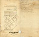
| Date: | 1850 |
|---|---|
| Description: | This map of Geneva shows lots and acreages, reserved land, and public squares. Streets and Lake Geneva are labeled. The map includes manuscript annotations... |

| Date: | 1857 |
|---|---|
| Description: | This map is ink and pencil on tracing paper. The map shows plats of a western section of Madison. The lakes are labeled "Fourth Lake", "Third Lake" and "La... |
If you didn't find the material you searched for, our Library Reference Staff can help.
Call our reference desk at 608-264-6535 or email us at: