Filter: Categories of Wisconsin Historical Images
Filter: Subject of Lakes
Filter: Year of 1800-1899
Filter: Subject of transportation
Filter: Categories of Wisconsin Historical Images
Filter: Subject of Lakes
Filter: Year of 1800-1899
Filter: Subject of transportation

| Date: | 1853 |
|---|---|
| Description: | Farwell's Mill on the Yahara River at Lake Mendota. |
| Date: | 1890 |
|---|---|
| Description: | The First Baptist Church, pictured in the lower center area of the photograph, organized in 1847 and erected in 1854. St. Raphael's Cathedral in the backgr... |
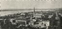
| Date: | 1893 |
|---|---|
| Description: | The rear view of the Ceylon Building, which was from the World's Columbian Exposition in Chicago. The building was later purchased by J.J. Mitchell, moved ... |
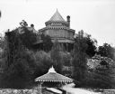
| Date: | 1893 |
|---|---|
| Description: | The Ceylon Building from the water, from the Columbian Exposition in Chicago. The building was later purchased by J.J. Mitchell and converted to a private ... |
| Date: | 1893 |
|---|---|
| Description: | The Ceylon Building and its pier as seen from Lake Geneva. Originally built for the World's Columbian Exposition in Chicago, the building was later purchas... |
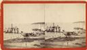
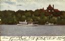
| Date: | 1880 |
|---|---|
| Description: | Stereograph elevated view of a steamboat landing in front of the Whiting House. Groups of people are standing on the pier, and more are on the steamboat. S... |
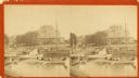
| Date: | 1880 |
|---|---|
| Description: | Stereograph view of a steamboat landing at Whiting House. |
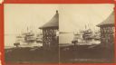
| Date: | 1880 |
|---|---|
| Description: | Stereograph view of the Whiting House with its large harbor and boats. Whiting House is a four-story wood frame Second Empire style hotel standing on the l... |

| Date: | 1844 |
|---|---|
| Description: | Map of Wisconsin including Lakes Michigan and Superior. Inset includes "N.W. Part of Wiskonsan." |

| Date: | 1856 |
|---|---|
| Description: | Isthmus of Madison, including Lake Mendota, or Great Lake, and Lake Menona [sic]. |

| Date: | 1890 |
|---|---|
| Description: | Left half of a plat map of the "East Part of the city of Madison". |

| Date: | 1890 |
|---|---|
| Description: | Right side of a plat map of the "East Part of the City of Madison". |

| Date: | 1890 |
|---|---|
| Description: | Portion of a plat map of the "West Part of the City of Madison". |
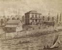
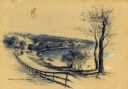
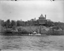
| Date: | 1872 |
|---|---|
| Description: | Drawing of and elevated view across water towards the Kendall residence, home of George L. Storer, a businessman in Madison. Three people are in a rowboat,... |

| Date: | 1855 |
|---|---|
| Description: | Map of the city of Madison, Dane County, published by George Harrison, surveyed and drawn by P. McCabe, and engraved by J.H. Colton & Co., New York. In add... |
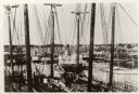
| Date: | 1887 |
|---|---|
| Description: | Some of the Old-Timers in the photograph: Steamers: Petosky (on stocks), Muskegon, Corona, A.D. Hayward, City of St. Joe, Lotus, J.F. Dayan, Grace Willia... |
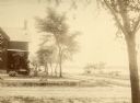
| Date: | 1875 |
|---|---|
| Description: | Exterior view of the Giles house, residence of Hiram H. Giles, state legislator and social welfare authority. |

| Date: | 1875 |
|---|---|
| Description: | Exterior view of the Giles house, residence of Hiram H. Giles, state legislator and social welfare authority. |

| Date: | 07 01 1836 |
|---|---|
| Description: | Original plat map of the town of Madison on the four lakes. |
If you didn't find the material you searched for, our Library Reference Staff can help.
Call our reference desk at 608-264-6535 or email us at: