 Filter: Categories of Wisconsin Historical Images
Filter: Subject of Lakes
Filter: Year of 1800-1899
Filter: Subject of apostle islands
Filter: Categories of Wisconsin Historical Images
Filter: Subject of Lakes
Filter: Year of 1800-1899
Filter: Subject of apostle islands

| Date: | 1884 |
|---|---|
| Description: | Panorama bird's-eye view of the town of Ashland, on Lake Superior, and the Apostle Islands. |
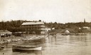
| Date: | 1890 |
|---|---|
| Description: | Old Mission Inn and boats on shoreline of Lake Superior on Madeline Island. The Old Mission Inn had numerous modifications over the years. It was razed in... |

| Date: | 1884 |
|---|---|
| Description: | A detailed, hand-colored map of Wisconsin and the western portion of Michigan’s Upper Peninsula, which also includes an inset of Isle Royale in Lake Superi... |

| Date: | 1888 |
|---|---|
| Description: | This map shows counties, lakes, railroads, and rivers. Lake Michigan, Lake Superior, and the Apostle Islands are labeled. A table of railroad lines with mi... |

| Date: | 1845 |
|---|---|
| Description: | This map shows lakes, rivers, Chippewa land, the U.S. Mineral Land Agency, boundary between U.S. and Canada, Methodist and Catholic missions, and American ... |

| Date: | 1847 |
|---|---|
| Description: | This map identifies surveyed areas of the Upper Peninsula and shows lakes, rivers, and islands in portions of Wisconsin, Minnesota, Michigan, and upper Can... |

| Date: | 1871 |
|---|---|
| Description: | This map shows railroads, canals, towns and some lighthouses. Areas of the company lands proper, tin, iron, gold & silver, silver islet, and lead are color... |
If you didn't find the material you searched for, our Library Reference Staff can help.
Call our reference desk at 608-264-6535 or email us at: