 Filter: Categories of Wisconsin Historical Images
Filter: Subject of Lakes
Filter: Subject of trees
Filter: Categories of Wisconsin Historical Images
Filter: Subject of Lakes
Filter: Subject of trees

| Date: | 10 17 1928 |
|---|---|
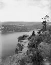
| Description: | View of the skyline of Madison from across Lake Monona at the Kilowatt clubhouse 5311 Tonyawatha Trail. |
| Date: | 07 29 1928 |
|---|---|
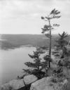
| Description: | Pine Point, high above Devil's Lake. |
| Date: | 07 29 1928 |
|---|---|
| Description: | Pine Point, high above Devil's Lake. |

| Date: | 06 16 1928 |
|---|---|
| Description: | Elevated view of near west side from the Loraine Hotel, showing the steeple of the First Congregational Church at 202 W. Washington Avenue in the foregroun... |
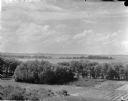
| Date: | 10 13 1927 |
|---|---|
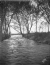
| Description: | Scenic view of outlet of Lake Mendota near Tenney Park and Yahara River. |
| Date: | 10 15 1927 |
|---|---|
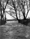
| Description: | Scenic view of outlet of Lake Mendota near Tenney Park and Yahara River. |
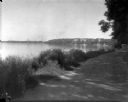
| Date: | 06 03 1927 |
|---|---|
| Description: | Lake Drive scenic view. The lake is in the background. |
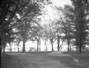
| Date: | 11 20 1926 |
|---|---|
| Description: | View from Observatory Hill of the new Men's Lakeshore dormitories at the University of Wisconsin-Madison, showing Chamberlin Rock in the foreground. The do... |
| Date: | 1926 |
|---|---|
| Description: | Lake Mendota, including Fraternity Row and east side shoreline, taken from the lake path on University Bay Drive. |
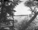
| Date: | 1926 |
|---|---|
| Description: | Elevated view of Picnic Point on Lake Mendota from the University of Wisconsin-Madison Soils building. |
| Date: | 1926 |
|---|---|
| Description: | View through willow trees on Picnic Point across University Bay of Lake Mendota on the University of Wisconsin-Madison campus. |
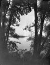
| Date: | 1926 |
|---|---|
| Description: | View of Picnic Point across University Bay on Lake Mendota. There is a willow tree in the foreground. People are in a canoe out on the water. |

| Date: | 06 30 1926 |
|---|---|
| Description: | View across Observatory Drive, looking down towards the Van Hise dormitories: Adams, Tripp, and Carson Gulley Commons. Picnic Point is in the distance on L... |

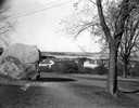
| Date: | 12 1925 |
|---|---|
| Description: | Elevated view of the Van Hise Dormitories under construction: Adams, Tripp, Carson Gulley Commons, and a view of Picnic Point, at the University of Wiscons... |

| Date: | 1870 |
|---|---|
| Description: | Birds-eye drawing of Oconomowoc depicts street names and street layouts, houses, trees, Oconomowoc River, Fowler Lake, and La Belle Lake. A reference key a... |

| Date: | 1870 |
|---|---|
| Description: | Bird's-eye view of Whitewater, with insets. |

| Date: | 1890 |
|---|---|
| Description: | Colored bird's-eye map of Oconomowoc and the Lake Region, Waukesha County. Looking North from Government Hill. Location key below image identifies 24 Hotel... |
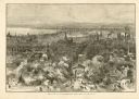
| Date: | 1882 |
|---|---|
| Description: | Bird's-eye view of Milwaukee looking south down 8th Street from Schlitz's Park. |
If you didn't find the material you searched for, our Library Reference Staff can help.
Call our reference desk at 608-264-6535 or email us at:

