 Filter: Categories of Wisconsin Historical Images
Filter: Subject of Lakes
Filter: Subject of public buildings
Filter: Categories of Wisconsin Historical Images
Filter: Subject of Lakes
Filter: Subject of public buildings
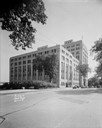
| Date: | 06 16 1941 |
|---|---|
| Description: | Wisconsin State Office Building, 1 West Wilson Street. Lake Monona is in the background. |
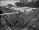
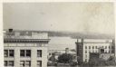
| Date: | 08 01 1930 |
|---|---|
| Description: | Basement and ground floor of State Office Building, 1 W. Wilson Street, under construction. View toward Lake Monona. |
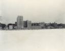
| Date: | 12 18 1955 |
|---|---|
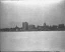
| Description: | Downtown Madison lakeshore taken from Lake Monona in a line with South Carroll Street. Includes State Office Building (2 wings only), 1 West Wilson Street,... |
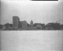
| Date: | 12 18 1955 |
|---|---|
| Description: | Downtown Madison shoreline taken from Lake Monona in line with Monona Avenue (Martin Luther King, Jr. Boulevard as of January 19, 1987). Includes Wisconsi... |

| Date: | 1915 |
|---|---|
| Description: | Wisconsin Avenue looking toward the northwest from the top of the Capitol. The elevated perspective provides an unusual view of the old City Hall (left) an... |

| Date: | 03 21 1949 |
|---|---|
| Description: | Elevated view from Wisconsin State Capitol, showing Main Street side of square, looking down Monona Avenue (Martin Luther King, Jr. Boulevard). Buildings i... |
| Date: | |
|---|---|
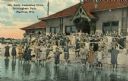
| Description: | A colorized image of a girls' swimming class at the Brittingham Park bathhouse. Caption reads: "Girls' Swimming Class, Brittingham Park, Madison, Wis." |
| Date: | 12 18 1955 |
|---|---|
| Description: | Downtown Madison lakeshore taken from Lake Monona in line with South Pinckney Street. Includes 1 West Wilson Street state office building, the Wisconsin St... |
| Date: | 1910 |
|---|---|
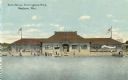
| Description: | View across water towards the bath house. Caption reads: "Bath House, Brittingham Park, Madison, Wis." |
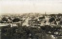
| Date: | 1870 |
|---|---|
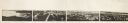
| Description: | Panoramic view of Madison, taken from the roof of South Hall. This reduced copy was made from original negatives by E.C. Nielson. Labels for both Lake Mend... |
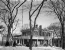
| Date: | 11 25 1947 |
|---|---|
| Description: | Wisconsin Governor's residence with snow on the ground, 130 East Gilman Street. The house was built for General Julius White in 1856. Succeeding owners wer... |
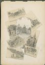
| Date: | 1885 |
|---|---|
| Description: | Wisconsin State Capitol surrounded by seven miniature drawings of Madison images. |

| Date: | 1928 |
|---|---|
| Description: | University of Wisconsin-Madison, looking west. Lake Mendota and Picnic Point are in the upper right of the image. Bascom Hall, the Red Gym, the Wisconsin H... |

| Date: | 06 09 1901 |
|---|---|
| Description: | View across water of rowboats and canoes on small lake, perhaps Lake Park. On the far shoreline a large crowd is gathered, and on a hill behind them a buil... |
| Date: | 1905 |
|---|---|
| Description: | Elevated view from the roof of the Wisconsin State Capitol looking west along State Street to Bascom Hall (with dome). The State Historical Society Buildin... |
| Date: | 1930 |
|---|---|
| Description: | Elevated view to the south from the Capitol Square. The large building on the left is the original first National Bank that was demolished to make way for ... |

| Date: | 06 16 1953 |
|---|---|
| Description: | View of a crowd of people, mostly in swimsuits, at what might be Vilas Beach on Lake Wingra. There is a concession stand in a building in the background. A... |

| Date: | |
|---|---|
| Description: | A person is driving a red Scout on a road in a park or recreation area. There is a park building in the background on the right, and a picnic table is near... |
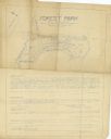
| Date: | 1934 |
|---|---|
| Description: | Blue line print plat map that shows block numbers and dimensions, West Cole Street, Covall Street, Balden St., Parshall Parkway, and the location of the ci... |
If you didn't find the material you searched for, our Library Reference Staff can help.
Call our reference desk at 608-264-6535 or email us at:
