 Filter: Categories of Wisconsin Historical Images
Filter: Subject of Lakes
Filter: Subject of city halls
Filter: Categories of Wisconsin Historical Images
Filter: Subject of Lakes
Filter: Subject of city halls
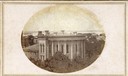
| Date: | 1861 |
|---|---|
| Description: | East (King Street) wing of the third Wisconsin State Capitol and the south wall of the Territorial Capitol (at the left) taken from the roof of the buildin... |

| Date: | 1915 |
|---|---|
| Description: | Wisconsin Avenue looking toward the northwest from the top of the Capitol. The elevated perspective provides an unusual view of the old City Hall (left) an... |

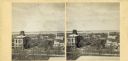
| Date: | 1868 |
|---|---|
| Description: | Elevated view up Wisconsin Avenue showing City Hall on the corner at Mifflin Street on the left, with the Post Office to the right. Further down is the Pre... |

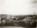
| Date: | 1895 |
|---|---|
| Description: | Panoramic view of Milwaukee looking northeast. City Hall is visible at the left and Lake Michigan can be seen at the upper right. |
| Date: | 1896 |
|---|---|
| Description: | View from the Wisconsin State Capitol dome looking west towards Bascom Hill. Mifflin street with City Hall and the Fuller Opera House are in the foreground... |

| Date: | 09 1954 |
|---|---|
| Description: | Elevated view of Wisconsin Avenue from the Wisconsin State Capitol balcony. At the lower left, the demolition of old City Hall is in progress, which began ... |

| Date: | 1954 |
|---|---|
| Description: | Looking northwest down Wisconsin Avenue from the Wisconsin State Capitol dome. Mifflin Street is visible in the foreground, while in the center of the phot... |
| Date: | |
|---|---|
| Description: | Elevated view up Wisconsin Avenue showing City Hall with the Post Office to the right. Also visible is the Presbyterian Church. |

| Date: | 1909 |
|---|---|
| Description: | A map of Langlade County, Wisconsin that shows townships and ranges, towns, cities and villages, wagon roads, churches, schools, sawmills, town halls, chee... |

| Date: | 1926 |
|---|---|
| Description: | A map of Lincoln County, Wisconsin that shows the township and range grid, towns, cities and villages, lakes and streams, residences, churches, school hous... |

| Date: | 1903 |
|---|---|
| Description: | This 1903 map of Outagamie County, Wisconsin, shows the township and range grid, towns, sections, cities and villages, landownership and acreages, rural ma... |

| Date: | |
|---|---|
| Description: | This 1907 map of Outagamie County, Wisconsin, shows the township and range grid, towns, sections, cities and villages, railroads, wagon roads, churches, sc... |

| Date: | 1922 |
|---|---|
| Description: | This map of Outagamie County, Wisconsin, from the first half of the 20th century, shows the township and range grid, towns, sections, cities and villages, ... |

| Date: | 1913 |
|---|---|
| Description: | This 1913 map of Pepin County, Wisconsin, shows the township and range grid, towns, villages, rural routes, railroads, roads, schools, churches, cemeteries... |

| Date: | 1922 |
|---|---|
| Description: | This map of Pierce County, Wisconsin, from the first half of the 20th century, shows the township and range grid, towns, sections, villages, roads, railroa... |

| Date: | |
|---|---|
| Description: | This map from the early 20th century shows the township and range grid, towns, sections, cities and villages, railroads, roads, schools, churches, cemeteri... |

| Date: | 1914 |
|---|---|
| Description: | This 1914 map of Price County, Wisconsin, shows land for sale by the Good Land Company and Dewitt van Ostrand of Phillips. Also shown are the township and ... |

| Date: | 1920 |
|---|---|
| Description: | This map shows the township and range system, sections, schools, churches, cemeteries, town halls, roads, railroads, and lakes and streams in Shawano Count... |

| Date: | 1918 |
|---|---|
| Description: | This 1918 map of Chippewa County, Wisconsin, shows the township and range grid, towns, sections, cities and villages, rural residences, churches, schools, ... |

| Date: | 1873 |
|---|---|
| Description: | Elevated view from Capitol Park of Madison City Hall with clock tower, 2 West Mifflin Street. Lake Mendota is in the far background. |
If you didn't find the material you searched for, our Library Reference Staff can help.
Call our reference desk at 608-264-6535 or email us at: