 Filter: Categories of Wisconsin Historical Images
Filter: Subject of Jewelry
Filter: Subject of rivers
Filter: Categories of Wisconsin Historical Images
Filter: Subject of Jewelry
Filter: Subject of rivers

| Date: | 1673 |
|---|---|
| Description: | P. Marquette en Joliet, gedan in't jaar 1673. |
| Date: | |
|---|---|
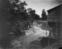
| Description: | Group of four men and a girl standing on the opposite shoreline by the falls, with probably the Charter Oak Mill on the right on Squaw Creek. |

| Date: | 1968 |
|---|---|
| Description: | A fashionably dressed young couple stand in an embrace on a pier on the East River. The river and a waterfront warehouse are visible behind them. |
| Date: | |
|---|---|
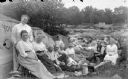
| Description: | Four men and seven women are posing sitting and standing around a picnic on the edge of a river, with a man standing on a bridge in the background. The fir... |

| Date: | |
|---|---|
| Description: | Exterior portrait next to a river of two men and three women posing sitting, and two men posing standing behind them. |
| Date: | 1882 |
|---|---|
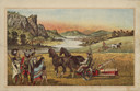
| Description: | Back cover of catalog with an illustration of two men using horse-drawn agricultural machinery in fields, while a group of Native American Indians look on.... |

| Date: | 1929 |
|---|---|
| Description: | Ho-Chunk women perform the Swan Dance. There is a group of men sitting in a circle next to them. |

| Date: | 1780 |
|---|---|
| Description: | Map of North and South America, showing the boundaries of colonial territories, cities, settlements, rivers, lakes, and Native American land. Particular em... |

| Date: | 1684 |
|---|---|
| Description: | Map of North America showing some colonies, cities, rivers, lakes, and Native American land. Ship routes spread across both oceans, including one decorated... |

| Date: | 1770 |
|---|---|
| Description: | Map of North America from the Great Lakes to the northern portion of South America. It shows cities, Native American land, mountains, swamps, lakes, rivers... |

| Date: | |
|---|---|
| Description: | Two young women, Annette Miner and Carolyn Young, are standing in water on a sand bar with a toy canoe floating nearby. |

| Date: | 1907 |
|---|---|
| Description: | Text on front reads: "Souvenir Folder, Menominee Indian Girl at Keshena Falls, Shawano, Wisconsin." She is sitting on a rock, posing in a blanket and indi... |
If you didn't find the material you searched for, our Library Reference Staff can help.
Call our reference desk at 608-264-6535 or email us at: