 Filter: Categories of Wisconsin Historical Images
Filter: Subject of Islands
Filter: Categories of Wisconsin Historical Images
Filter: Subject of Islands

| Date: | 1862 |
|---|---|
| Description: | This map lists and depicts the positions of "the batteries on Kentucky shore" and the "batteries on Island No. 10." The 8th Wisconsin Infantry and 15th Wis... |

| Date: | |
|---|---|
| Description: | Capital Island Wheat beer label. The label features a drawing of the Wisconsin Capitol dome flanked by stalks of wheat. There is also a map of Washington I... |
| Date: | 1937 |
|---|---|
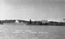
| Description: | View from the lake of the summer homes on Nebraska Row along the shoreline of Lake Superior. The water tower and church steeple are visible on the far righ... |
| Date: | 1939 |
|---|---|
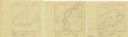
| Description: | A survey map of Island Lake in Bayfield County, Wisconsin, Chain Lake in Rusk and Chippewa counties, and Manson Lake in Oneida County. The maps show the de... |

| Date: | 1856 |
|---|---|
| Description: | A hand-colored map of Wisconsin, showing the county boundaries, towns, cities, railroads, roads, lakes, rivers, bays, and the Lake Superior’s islands. In ... |

| Date: | 1939 |
|---|---|
| Description: | This map shows the towns to Gingles, Sanborn, and Guney as well as Chequamegon Bay, Kakagon River, White River, Marengo River, Bad River, Potato River, Vau... |

| Date: | 1862 |
|---|---|
| Description: | This map of the Mississippi River between Island No. 8, northeast of New Madrid, Missouri, and Tiptonville, Tennessee, depicts the Confederate defenses at ... |
| Date: | 1938 |
|---|---|
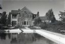
| Description: | View of the two-story, wood shingle, lake shore home, Woods Manor, a part of Nebraska Row on Madeline Island. In the foreground is a swimming pool surround... |

| Date: | 1938 |
|---|---|
| Description: | View of a house on Nebraska Row on Madeline Island. In the foreground is a flag pole, bench, path, lawn and trees. On the left are docks from the lake shor... |
| Date: | 1856 |
|---|---|
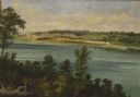
| Description: | "At the Grand Kakalin where the river runs almost directly eastward, Brookes and Stevenson paused to paint two scenes. One was a broad landscape showing th... |

| Date: | 1875 |
|---|---|
| Description: | Map of the triangulations made from Vulcan on the Keweenaw Peninsula in the Upper Peninsula of Michigan south through eastern Wisconsin, past Chicago to Ba... |

| Date: | 1884 |
|---|---|
| Description: | A detailed, hand-colored map of Wisconsin and the western portion of Michigan’s Upper Peninsula, which also includes an inset of Isle Royale in Lake Superi... |
| Date: | |
|---|---|
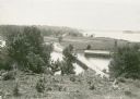
| Description: | Elevated view overlooking a road leading toward water, a boathouse, cabins, and a lake, most likely Jackson Lake. The shoreline on the far top right is ide... |

| Date: | |
|---|---|
| Description: | View of a dirt road, cleared land, Jackson Lake and shoreline. Off to the far right is where the Nature Lovers Paradise resort cottages were located. A sig... |

| Date: | 1915 |
|---|---|
| Description: | A map showing the location of post offices in Wisconsin and Michigan that were in operation as of April, 1915, along with the mail routes in use as well as... |
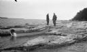
| Date: | 1923 |
|---|---|
| Description: | Two men, including Ferdinand L. (Fedy) Hotz, left, stand on the west shore of Spider Island off Door County. There is a small boat with an outboard motor ... |
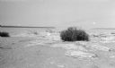
| Date: | 07 1923 |
|---|---|
| Description: | A grassy hummock stands out on the beach at Gravelly Island. |
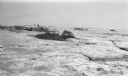
| Date: | 07 1923 |
|---|---|
| Description: | Members of the photographer's family shield their heads with their clothing while walking among grassy hummocks on Gravelly Island. There are many seagulls... |
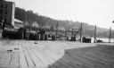
| Date: | 07 1923 |
|---|---|
| Description: | View of Mackinac Island from a wooden pier. There are large houses, some with turrets, facing the water. |
If you didn't find the material you searched for, our Library Reference Staff can help.
Call our reference desk at 608-264-6535 or email us at:
