 Filter: Categories of Wisconsin Historical Images
Filter: Subject of Islands
Filter: Year of 1800-1899
Filter: Subject of botany
Filter: Categories of Wisconsin Historical Images
Filter: Subject of Islands
Filter: Year of 1800-1899
Filter: Subject of botany

| Date: | 1856 |
|---|---|
| Description: | This landscape painting by Samuel Marsden Brookes and Thomas H. Stevenson depicts a broad view of the confluence of Bad Axe and Mississippi Rivers; site of... |

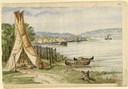
| Date: | 1852 |
|---|---|
| Description: | Illustration of four Indians on Madeline Island with a canoe in the water on the shore. |
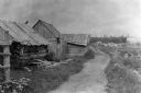
| Date: | 1897 |
|---|---|
| Description: | Dirt trail passing log shack that was probably the home of Michael and Madeline Cadotte. |

| Date: | 1898 |
|---|---|
| Description: | Old Mission Residence at La Pointe, Madeline Island. |

| Date: | 1850 |
|---|---|
| Description: | Pastoral scene depicting a small bay on the Island of St. Ignace in Lake Superior with canoes on the rocky beach, two men conversing on a blanket in the fo... |

| Date: | 1850 |
|---|---|
| Description: | Pic Island on the north shore of Lake Superior. |
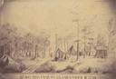
| Date: | 1862 |
|---|---|
| Description: | Sketch of the camp of the 15th Regiment of the Wisconsin Volunteer Infantry on Island No. 10 during the Civil War. Colonel Hans Christian Heg commanded the... |

| Date: | 1867 |
|---|---|
| Description: | Birds-eye drawing of Appleton, Outagamie Co., depicting street names and street layout, houses, the Fox River, the court house, jail, school houses, Lawren... |

| Date: | 1870 |
|---|---|
| Description: | Bird's-eye map of Prairie du Sac. |

| Date: | 1874 |
|---|---|
| Description: | Bird's-eye map of Chippewa Falls. |

| Date: | 1872 |
|---|---|
| Description: | Birds-eye drawing of Eau Claire depicts street names and street locations, houses, trees, bridges, piers, canals, railroads, and the Chippewa and Eau Clair... |

| Date: | 1870 |
|---|---|
| Description: | Birds-eye drawing of Oconomowoc depicts street names and street layouts, houses, trees, Oconomowoc River, Fowler Lake, and La Belle Lake. A reference key a... |

| Date: | 1883 |
|---|---|
| Description: | Bird's-eye map of Prairie du Sac, Wisconsin with an inset of Clifton. |

| Date: | 1883 |
|---|---|
| Description: | Bird's-eye map of Sauk City. |

| Date: | 1879 |
|---|---|
| Description: | Bird's-eye map of Two Rivers. |

| Date: | 1879 |
|---|---|
| Description: | This map is a bird's-eye view of Wausau, the County Seat of Marathon County. The map features an index of points of interest. |

| Date: | 1890 |
|---|---|
| Description: | Colored bird's-eye map of Oconomowoc and the Lake Region, Waukesha County. Looking North from Government Hill. Location key below image identifies 24 Hotel... |
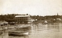
| Date: | 1890 |
|---|---|
| Description: | Old Mission Inn and boats on shoreline of Lake Superior on Madeline Island. The Old Mission Inn had numerous modifications over the years. It was razed in... |
| Date: | 1860 |
|---|---|
| Description: | In April of 1860 Hölzlhuber took the railway from Milwaukee to Lake Horicon to visit the small town that was developing on its shore. Since the settlers we... |
If you didn't find the material you searched for, our Library Reference Staff can help.
Call our reference desk at 608-264-6535 or email us at:
