 Filter: Categories of Wisconsin Historical Images
Filter: Subject of Islands
Filter: Subject of trails
Filter: Categories of Wisconsin Historical Images
Filter: Subject of Islands
Filter: Subject of trails
| Date: | |
|---|---|
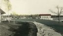
| Description: | Hand-colored view of the Thordarson estate including the boathouse and a stone-paved path with benches. |
| Date: | |
|---|---|
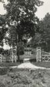
| Description: | The entrance to the garden framed by a decorative wooden gate. |

| Date: | 1938 |
|---|---|
| Description: | View of a house on Nebraska Row on Madeline Island. In the foreground is a flag pole, bench, path, lawn and trees. On the left are docks from the lake shor... |

| Date: | 1916 |
|---|---|
| Description: | This Wisconsin Conservation Commission map from 1916 shows Peninsula State Park in the Town of Gibraltar, Door County, Wisconsin. Depicted are open and pla... |

| Date: | 1916 |
|---|---|
| Description: | This version of a 1916 Wisconsin Conservation Commission map shows Peninsula State Park in the Town of Gibraltar, Door County, Wisconsin. Depicted are open... |

| Date: | 1925 |
|---|---|
| Description: | This 1925 map of Ashland County, Wisconsin, shows the township and range system, towns, sections, cities and villages, the Bad River Indian Reservation, ra... |

| Date: | 1952 |
|---|---|
| Description: | This map of the northern parts of the Chequamegon Bay area in Bayfield and Ashland counties, Wisconsin, shows trails, roads, railroads, stations, the towns... |
| Date: | 1913 |
|---|---|
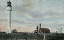
| Description: | Hand-colored postcard showing the lighthouse and fog signal at Devil's Island in the Apostle Islands. Caption reads: "Apostle Islands, Wis. Devil's Island,... |

| Date: | 08 24 1899 |
|---|---|
| Description: | Pen-and-ink and color on paper. Also shows probable routes of the French explorers Constant le Marchand de Lignery in 1728 and Louis de la Porte de Louvign... |

| Date: | 1800 |
|---|---|
| Description: | This map of the Little Kaukalin Region is ink on paper and shows Little Kaukalin Rapids, Black Bird Island, buildings, trails, meadows and woods, and a sug... |

| Date: | 1936 |
|---|---|
| Description: | This map shows campsites, trails, auto roads, surrounding townships, and points of interest, by including pictorial illustrations. Includes an inserted map... |

| Date: | 1912 |
|---|---|
| Description: | A man, wearing a turtleneck and pants, is pushing a wheelbarrow filled with birch bark on a grassy path under tall trees on the Island at Archibald Lake. |

| Date: | 1911 |
|---|---|
| Description: | View down trail towards a small group of women and girls hiking in Cathedral Woods on a sunny day. The old growth forest is made up of pines and hemlocks. |

| Date: | 1911 |
|---|---|
| Description: | View down the first part of the path to Cathedral Woods from Barn Pond. The logs laid lengthwise and crosswise help one across the bog into the forest prop... |
If you didn't find the material you searched for, our Library Reference Staff can help.
Call our reference desk at 608-264-6535 or email us at: