Filter: Categories of Wisconsin Historical Images
Filter: Subject of Islands
Filter: Subject of schools
Filter: Categories of Wisconsin Historical Images
Filter: Subject of Islands
Filter: Subject of schools
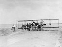
| Date: | 03 07 1912 |
|---|---|
| Description: | Students of the Curtiss School of Aviation on North Island moving a plane into position for a lesson. |
| Date: | 1912 |
|---|---|
| Description: | Photo opportunity day at the Glenn Curtiss School of Aviation on North Island in San Diego Harbor. The man in the lower left corner is thought to be Glenn ... |

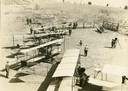
| Date: | 05 1912 |
|---|---|
| Description: | The 1912 class at the Glenn Curtiss Aviation School on North Island, near San Diego. Milwaukee's John Kaminski (in white shirt and tie) is second from the ... |
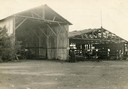
| Date: | 1912 |
|---|---|
| Description: | Hangars of the Curtiss Aviation School and the San Diego Aero Club on North Island in San Diego Harbor. Glenn Curtiss himself is thought to be the individu... |

| Date: | 1872 |
|---|---|
| Description: | Birds-eye drawing of Eau Claire depicts street names and street locations, houses, trees, bridges, piers, canals, railroads, and the Chippewa and Eau Clair... |

| Date: | 1879 |
|---|---|
| Description: | This map is a bird's-eye view of Wausau, the County Seat of Marathon County. The map features an index of points of interest. |
| Date: | |
|---|---|
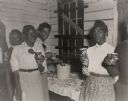
| Description: | Wadmalaw Island Citizenship group coffee break. Third from the left is Bernice Robinson, a teacher in the first school, former Highlander Folk School stud... |
| Date: | |
|---|---|
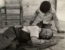
| Description: | Two children waiting for their parents at the Wadmalaw Citizenship School. |
| Date: | |
|---|---|
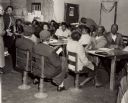
| Description: | Mrs. Brewer teaching a citizenship class at Edisto Island. Septima Clark, far left. |

| Date: | 1913 |
|---|---|
| Description: | A wall atlas of Sauk County, Wisconsin, displaying its 22 towns. On the left side are advertisements for local businesses. |

| Date: | 1939 |
|---|---|
| Description: | This map shows the towns to Gingles, Sanborn, and Guney as well as Chequamegon Bay, Kakagon River, White River, Marengo River, Bad River, Potato River, Vau... |

| Date: | 1915 |
|---|---|
| Description: | Elevated view, looking north, from the Hotz family compound near the bluff entrance to Fish Creek. Evergreens and bare birch trees stand in the foreground,... |

| Date: | 1859 |
|---|---|
| Description: | This map show plats including plat names, plat numbers, and some lot owner's names. Relief is shown by hachures. The map includes line drawings of Juneau B... |

| Date: | 1936 |
|---|---|
| Description: | This map shows campsites, trails, auto roads, surrounding townships, and points of interest, by including pictorial illustrations. Includes an inserted map... |
If you didn't find the material you searched for, our Library Reference Staff can help.
Call our reference desk at 608-264-6535 or email us at: