 Filter: Categories of Wisconsin Historical Images
Filter: Subject of Islands
Filter: Subject of railroads
Filter: Categories of Wisconsin Historical Images
Filter: Subject of Islands
Filter: Subject of railroads

| Date: | 1881 |
|---|---|
| Description: | Bird's-eye map of Marinette, with insets. |

| Date: | 1886 |
|---|---|
| Description: | Bird's-eye view of Ashland, on the shores of Lake Superior, with insets of The Apostle Islands Chequamagon Bay & Ashland, and Distances from Ashland. |

| Date: | 1867 |
|---|---|
| Description: | Birds-eye drawing of Appleton, Outagamie Co., depicting street names and street layout, houses, the Fox River, the court house, jail, school houses, Lawren... |

| Date: | 1886 |
|---|---|
| Description: | Bird's-eye map of Washburn on Lake Superior. There is an inset of Washburn, Chequamagon and the Apostle Islands. |

| Date: | 1875 |
|---|---|
| Description: | Bird's-eye map of Black River Falls, looking southwest. |

| Date: | 1874 |
|---|---|
| Description: | Bird's-eye map of Chippewa Falls. |

| Date: | 1872 |
|---|---|
| Description: | Birds-eye drawing of Eau Claire depicts street names and street locations, houses, trees, bridges, piers, canals, railroads, and the Chippewa and Eau Clair... |

| Date: | 1870 |
|---|---|
| Description: | Birds-eye drawing of Oconomowoc depicts street names and street layouts, houses, trees, Oconomowoc River, Fowler Lake, and La Belle Lake. A reference key a... |

| Date: | 1883 |
|---|---|
| Description: | Bird's-eye map of Prairie du Sac, Wisconsin with an inset of Clifton. |

| Date: | 1891 |
|---|---|
| Description: | Bird's-eye map of Stevens Point, looking east, with an inset of the Water Works. Wisconsin River in foreground with fifty-three business locations identifi... |

| Date: | 1879 |
|---|---|
| Description: | Bird's-eye map of Two Rivers. |

| Date: | 1910 |
|---|---|
| Description: | Bird's-eye view looking east, with Washburn Harbor at center and Chequamegon Bay in Lake Superior covering most of the upper image. Streets with buildings... |

| Date: | 1879 |
|---|---|
| Description: | This map is a bird's-eye view of Wausau, the County Seat of Marathon County. The map features an index of points of interest. |
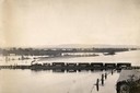
| Date: | |
|---|---|
| Description: | Elevated view of the pile-pontoon railroad bridge across the Mississippi River at Prairie du Chien. The bridge was built and patented by John Lawler in 187... |
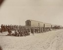
| Date: | 10 1898 |
|---|---|
| Description: | A cavalry troop from the Ojibwa-Pillager Battle at Sugar Point on Bear Island gathers near a train. |

| Date: | |
|---|---|
| Description: | Plat map of the east central part of the city. |

| Date: | 1913 |
|---|---|
| Description: | A wall atlas of Sauk County, Wisconsin, displaying its 22 towns. On the left side are advertisements for local businesses. |

| Date: | 1856 |
|---|---|
| Description: | A hand-colored map of Wisconsin, showing the county boundaries, towns, cities, railroads, roads, lakes, rivers, bays, and the Lake Superior’s islands. In ... |
If you didn't find the material you searched for, our Library Reference Staff can help.
Call our reference desk at 608-264-6535 or email us at:

