Filter: Categories of Wisconsin Historical Images
Filter: Subject of Islands
Filter: Subject of michigan, lake
Filter: Categories of Wisconsin Historical Images
Filter: Subject of Islands
Filter: Subject of michigan, lake
| Date: | |
|---|---|
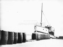
| Description: | The screw ferry, "Wisconsin," docked at Washington Island. Twenty-one metal drums line the edge of the dock in the foreground. Original is in scrapbook on ... |

| Date: | |
|---|---|
| Description: | Map of the district of the Peshtigo fire, approximately 1,280,000 acres, in Wisconsin and Upper Michigan. |

| Date: | 1879 |
|---|---|
| Description: | Bird's-eye map of Two Rivers. |

| Date: | 1892 |
|---|---|
| Description: | Bird's-eye view of the Columbian Exposition pavilions from the vantage point of Lake Michigan. Included is an inset of the Union Passenger Station (now Uni... |

| Date: | 1929 |
|---|---|
| Description: | Ferryboat landing, with the boats providing service between Gills Rock and Washington Island. |

| Date: | 1844 |
|---|---|
| Description: | Map of Wisconsin including Lakes Michigan and Superior. Inset includes "N.W. Part of Wiskonsan." |
| Date: | 1910 |
|---|---|
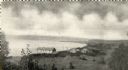
| Description: | View of Sawyer Harbor as seen from Government Bluff. |

| Date: | 1907 |
|---|---|
| Description: | The Ruins of the old Light House on Plum Island near Sturgeon Bay. Caption at bottom reads: "Ruins of Old Light House on Plum Island," "Made expressly for ... |

| Date: | 1910 |
|---|---|
| Description: | Wisconsin Geological and Natural History Survey, by Lawrence Martin reproduced from a model of the state prepared by W.O. Hotchkiss and F.T. Thwaites and m... |

| Date: | 1954 |
|---|---|
| Description: | View looking west from Eagle Bluff toward Nicolet Bay, the Strawberry Islands, and Chambers Island. Three people are sitting on the stone wall of the overl... |

| Date: | 1951 |
|---|---|
| Description: | Aerial view of Jones Island and garbage disposal plant. |

| Date: | 1950 |
|---|---|
| Description: | Harbor area of Jones Island and garbage disposal plant, Stratton Grain Co., and more. |
| Date: | 1902 |
|---|---|
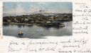
| Description: | Elevated view of island with houses and boathouses and boats along the shoreline. Industrial buildings are in the background, and a sailboat is on the wate... |
| Date: | 1961 |
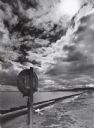
|---|---|
| Description: | Shoreline of Lake Michigan. This is mainly a commercial fishing community, and some of the Lake Michigan ferry boats dock here. A pole with a lifesaving ri... |
| Date: | 10 28 1938 |
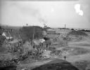
|---|---|
| Description: | Elevated view of a cluster of old dwellings in the center, with broken shacks and rusted cars. In the background are railroad cars, and an industrial area ... |
| Date: | 10 28 1938 |
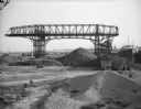
|---|---|
| Description: | Men working near large dredge on Jones Island. Large piles of material are on the ground below the dredge. There is a ship on the right. In the distance a... |

| Date: | 1920 |
|---|---|
| Description: | Thorstein Veblen sitting on a beach, probably at Washington Island, surrounded by driftwood. There is a young child on the beach on the right. |

| Date: | 08 18 1963 |
|---|---|
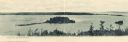
| Description: | Elevated view of a small, gravelly island in Lake Michigan. Caption on photograph reads, "Green Bay shore with small gravely island. This is very likely th... |
If you didn't find the material you searched for, our Library Reference Staff can help.
Call our reference desk at 608-264-6535 or email us at: