 Filter: Categories of Wisconsin Historical Images
Filter: Subject of Islands
Filter: Subject of church buildings
Filter: Categories of Wisconsin Historical Images
Filter: Subject of Islands
Filter: Subject of church buildings
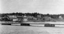
| Date: | 1920 |
|---|---|
| Description: | View from the water of the Mission, dock, Mission cottages, and Congregational Church on Madeline Island. |
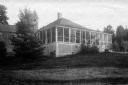
| Date: | 1913 |
|---|---|
| Description: | View across lawn of the Church Cottage and Congregational Church on Madeline Island. |

| Date: | 1886 |
|---|---|
| Description: | Bird's-eye view of Bayfield, county seat of Bayfield County. On the lower left side is an inset for Bayfield and the Apostle Islands. |

| Date: | 1867 |
|---|---|
| Description: | Birds-eye drawing of Appleton, Outagamie Co., depicting street names and street layout, houses, the Fox River, the court house, jail, school houses, Lawren... |

| Date: | 1870 |
|---|---|
| Description: | Bird's-eye map of Prairie du Sac. |

| Date: | 1875 |
|---|---|
| Description: | Bird's-eye map of Black River Falls, looking southwest. |

| Date: | 1874 |
|---|---|
| Description: | Bird's-eye map of Chippewa Falls. |

| Date: | 1872 |
|---|---|
| Description: | Birds-eye drawing of Eau Claire depicts street names and street locations, houses, trees, bridges, piers, canals, railroads, and the Chippewa and Eau Clair... |

| Date: | 1870 |
|---|---|
| Description: | Birds-eye drawing of Oconomowoc depicts street names and street layouts, houses, trees, Oconomowoc River, Fowler Lake, and La Belle Lake. A reference key a... |

| Date: | 1883 |
|---|---|
| Description: | Bird's-eye map of Prairie du Sac, Wisconsin with an inset of Clifton. |

| Date: | 1891 |
|---|---|
| Description: | Bird's-eye map of Stevens Point, looking east, with an inset of the Water Works. Wisconsin River in foreground with fifty-three business locations identifi... |

| Date: | 1879 |
|---|---|
| Description: | Bird's-eye map of Two Rivers. |

| Date: | 1910 |
|---|---|
| Description: | Bird's-eye view looking east, with Washburn Harbor at center and Chequamegon Bay in Lake Superior covering most of the upper image. Streets with buildings... |

| Date: | 1879 |
|---|---|
| Description: | This map is a bird's-eye view of Wausau, the County Seat of Marathon County. The map features an index of points of interest. |
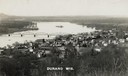
| Date: | 1910 |
|---|---|
| Description: | Elevated view of Durand from a high vantage point, looking towards the river. A bridge spans the river, and in the foreground just below the hill is a chur... |
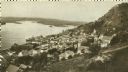
| Date: | 1920 |
|---|---|
| Description: | Elevated view of Fountain City with the Mississippi River in the background. |
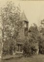
| Date: | 1940 |
|---|---|
| Description: | The Old Mission Congregational Church. The church was built in 1832 for a mission founded by Frederick Ayer in 1830. It is said to be the oldest Protestant... |
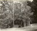
| Date: | 1915 |
|---|---|
| Description: | The Old Mission Congregational Church. The church was built in 1832 for a mission founded by Frederick Ayer in 1830. It is said to be the oldest Protestant... |
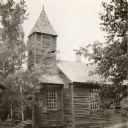
| Date: | 1940 |
|---|---|
| Description: | The Old Mission Congregational Church. The church was built in 1832 for a mission founded by Frederick Ayer in 1830. It is said to be the oldest Protestant... |
If you didn't find the material you searched for, our Library Reference Staff can help.
Call our reference desk at 608-264-6535 or email us at:
