 Filter: Categories of Wisconsin Historical Images
Filter: Subject of Islands
Filter: Subject of arts
Filter: Categories of Wisconsin Historical Images
Filter: Subject of Islands
Filter: Subject of arts

| Date: | 1900 |
|---|---|
| Description: | A group of immigrants, both children and adults, who have just arrived at Ellis Island. |
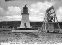
| Date: | 1908 |
|---|---|
| Description: | A view of the Prudence Island granite lighthouse, established in 1852 and automated in 1972, more commonly known locally as the Sandy Point Lighthouse. The... |

| Date: | 1884 |
|---|---|
| Description: | Cover art for a pamphlet advertising The Apostle Islands and Lake Superior. The upper half of the artwork depicts a sunset view of Lake Superior, and the b... |

| Date: | |
|---|---|
| Description: | Bird's-eye view lithograph of Key West with ships and smaller boats in the surrounding waters. |

| Date: | |
|---|---|
| Description: | Capital Island Wheat beer label. The label features a drawing of the Wisconsin Capitol dome flanked by stalks of wheat. There is also a map of Washington I... |

| Date: | 06 17 1900 |
|---|---|
| Description: | Children and adults standing near a figural fountain on Concordia, later Tovoli, Island. |

| Date: | 1831 |
|---|---|
| Description: | Map of the city of Louisville, Kentucky on the Ohio River showing streets and numbered lots. The Ohio River, Corn Island, and the Louisville and Portland C... |

| Date: | 1828 |
|---|---|
| Description: | Map of the Louisville and Portland Canal on the Ohio River. The map shows Louisville, Shippingsport, Clarksville, Jeffersonville, Gravel Island, Corn Islan... |

| Date: | 1941 |
|---|---|
| Description: | Elevated view of Sturgeon Bay in 1900. Sturgeon Bay Bridge spans the bay and several boats are on the water. A lighthouse sits on a small island in the bay... |

| Date: | 1720 |
|---|---|
| Description: | Double hemispherical world map showing routes of Tasman, Magellan, Mendana, etc. Relief shown pictorially. Title in oak wreath cartouche. Map between four ... |

| Date: | 1712 |
|---|---|
| Description: | Engraved double-hemispherical world map by Moll, included in his atlas The world described, or, A new and correct sett of maps: shewing the kingdoms and st... |

| Date: | 1696 |
|---|---|
| Description: | Engraved and hand-colored map of Ethiopia, from Blaeu's General Atlas. Map title is framed by a man and a woman, both wearing head turbans, who are standin... |

| Date: | 1798 |
|---|---|
| Description: | Engraved and hand-colored map of Egypt. Map title appears on bottom left as a carving in stone next ... |

| Date: | 1740 |
|---|---|
| Description: | Engraved and hand-colored map of the Iberian peninsula as a theater of war during the War of the Spanish Succession (1701-1714). The map is dedicated to Ki... |

| Date: | 1785 |
|---|---|
| Description: | Map of part of North America engraved and hand-colored (the light brown design is a superposition of the map and cartouche derived from the oxidation of th... |

| Date: | 03 24 1950 |
|---|---|
| Description: | Front cover of a farewell dinner menu from the Italian Line ship Saturnia, with two Commedia dell' Arte characters: Tartaglia, a rotund figure who w... |

| Date: | |
|---|---|
| Description: | Letterhead of Johnson & Melaas, merchant tailors and cloth dealers, "Buyers of wool and Wisconsin leaf tobacco," with an engraving of a waterfront view of ... |

| Date: | 1786 |
|---|---|
| Description: | This map is an updated version of d'Anville's 1761 map of the western hemisphere. He included more details to the north west coast of North America, partic... |

| Date: | 1786 |
|---|---|
| Description: | One half of a four sheet nautical chart, showing the coastlines of the north-west hemisphere. The interior lands are left bare, even of basic features such... |
If you didn't find the material you searched for, our Library Reference Staff can help.
Call our reference desk at 608-264-6535 or email us at:
