 Filter: Categories of Wisconsin Historical Images
Filter: Subject of International relations
Filter: Subject of men
Filter: Categories of Wisconsin Historical Images
Filter: Subject of International relations
Filter: Subject of men

| Date: | 1710 |
|---|---|
| Description: | Map of North America showing the European claims, Native American land and villages, rivers, lakes, cities, and notes on explorers, discoveries, and topogr... |

| Date: | 1766 |
|---|---|
| Description: | This map of North America shows the boundaries of European claims at the end of the French and Indian war. The British colonies extend to the Mississippi. ... |

| Date: | 1733 |
|---|---|
| Description: | This map of North America shows settlements, rivers, lakes, Native American land, trade winds, and numerous topographical features such as forests and moun... |

| Date: | 1770 |
|---|---|
| Description: | Map of North America from the Great Lakes to the northern portion of South America. It shows cities, Native American land, mountains, swamps, lakes, rivers... |
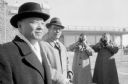
| Date: | 02 19 1958 |
|---|---|
| Description: | Hollington K. Tong, Nationalist China Ambassador to the United States (left) and O.C. Akre, Madison representative of Northwest Orient Airlines (center) ar... |
If you didn't find the material you searched for, our Library Reference Staff can help.
Call our reference desk at 608-264-6535 or email us at: