 Filter: Categories of Wisconsin Historical Images
Filter: Subject of Inland water transportation
Filter: Subject of mississippi river
Filter: Categories of Wisconsin Historical Images
Filter: Subject of Inland water transportation
Filter: Subject of mississippi river

| Date: | 1873 |
|---|---|
| Description: | Bird's-eye map of La Crosse from the Mississippi River. |

| Date: | 1884 |
|---|---|
| Description: | Bird's-eye view drawing of the grounds of Villa Louis, the estate of the fur trading Dousman family. After the death of H. Louis Dousman's mother in 1882, ... |
| Date: | |
|---|---|
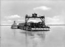
| Description: | View across water toward a railroad train and locomotive on a ferry going across the Mississippi River near New Orleans. |
| Date: | |
|---|---|
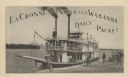
| Description: | Steamboat on the shoreline of the Mississippi River with passengers. Caption reads: "La Crosse, Winona and Wabasha Daily Packet." |
| Date: | |
|---|---|
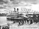
| Description: | View from shoreline towards a docked Mississippi riverboat. Passengers are disembarking from the ship, and a large crowd is gathered on shore, with some pe... |
| Date: | |
|---|---|
| Description: | View from shoreline of two passenger steamboats on the Mississippi river near Clinton. Several children and adults wait on shore. A tugboat is nearby in th... |
| Date: | |
|---|---|
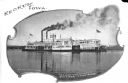
| Description: | Steamship "Saint Paul" on the Mississippi River near Keokuk. Sign painted on the ship read: "St. Louis, Quincy & Keokuk Jo Line Saint Paul." Postcard reads... |
| Date: | |
|---|---|
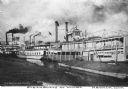
| Description: | View of several steamboats docked at the wharf. The ship on the right is the "Silver Crescent." The ship on the far left bears the logo "St. Louis Quincy &... |
| Date: | |
|---|---|
| Description: | View of the steamship "J.S." in the Mississippi River near Keokuk. Passengers are on board the ship decks, and the initials "J.S." are on the top portion o... |
| Date: | |
|---|---|
| Description: | View of the steamboat "Dubuque" docked in the Mississippi River. Passengers are on the ship decks and smoke is coming out of several nearby smokestacks. Ca... |
| Date: | |
|---|---|
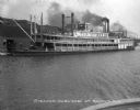
| Description: | View of the steamship "Fred Herold" in the Mississippi River near Cairo. "Fred Herold" is painted on the ship, and "Lee Line St. Louis & Memphis" is painte... |

| Date: | |
|---|---|
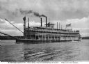
| Description: | View of the steamboat "Cape Girardeau" in the Mississippi River near Cape Girardeau. Many passengers are on the ship decks. The sign on the ship reads: "So... |

| Date: | |
|---|---|
| Description: | View of the steamship "Cape Girardeau" in the Mississippi River near Cape Girardeau. Many passengers are on board the ship, which is preparing to land. The... |

| Date: | |
|---|---|
| Description: | View from shoreline of the steamship "Cape Girardeau" in the Mississippi River near Cape Girardeau. Many passengers are on board the ship as it prepares to... |
| Date: | |
|---|---|
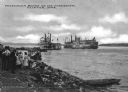
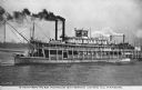
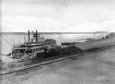
| Description: | Elevated view of the steamboat "Bald Eagle" unloading on the riverfront. "Bald Eagle" is painted on the top of the ship. Several men are working on and nea... |

| Date: | 1873 |
|---|---|
| Description: | Map of Wisconsin showing counties, county seats, cities with populations over 3,000, and congressional districts. The map also includes rivers, lakes, rail... |

| Date: | 1915 |
|---|---|
| Description: | View from shoreline of ferry carrying three automobiles on the Mississippi River. An excursion boat is in the water nearby, and buildings are on the far sh... |

| Date: | 1875 |
|---|---|
| Description: | This map, from G.K. Warren's 1876 Report on the transportation route along the Wisconsin and Fox rivers in the State of Wisconsin between the Mississippi R... |

| Date: | 1875 |
|---|---|
| Description: | These maps, from G.K. Warren's 1876 Report on the transportation route along the Wisconsin and Fox rivers in the State of Wisconsin between the Mississippi... |

| Date: | 1887 |
|---|---|
| Description: | Map of the Fox and Wisconsin Rivers to accompany Reuben Gold Thwaites' Historic Waterways. |
If you didn't find the material you searched for, our Library Reference Staff can help.
Call our reference desk at 608-264-6535 or email us at: