 Filter: Categories of Wisconsin Historical Images
Filter: Subject of Inland water transportation
Filter: Subject of michigan, lake
Filter: Categories of Wisconsin Historical Images
Filter: Subject of Inland water transportation
Filter: Subject of michigan, lake
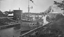
| Date: | |
|---|---|
| Description: | Elevated view of the "City of Charlevoix" ship coming into harbor. The sign painted on the front of the ship reads: "Northern Michigan Line" and "City of C... |

| Date: | 1873 |
|---|---|
| Description: | Map of Wisconsin showing counties, county seats, cities with populations over 3,000, and congressional districts. The map also includes rivers, lakes, rail... |

| Date: | 1875 |
|---|---|
| Description: | This map, from G.K. Warren's 1876 Report on the transportation route along the Wisconsin and Fox rivers in the State of Wisconsin between the Mississippi R... |

| Date: | 1875 |
|---|---|
| Description: | These maps, from G.K. Warren's 1876 Report on the transportation route along the Wisconsin and Fox rivers in the State of Wisconsin between the Mississippi... |

| Date: | |
|---|---|
| Description: | Aerial photograph of the Port of Kenosha and factories, with snow on the ground. There are four ships along the shoreline, and multiple factories on either... |

| Date: | 06 14 1961 |
|---|---|
| Description: | Aerial view of North and South Harbor Tracts, looking north from South Pier No. 2. There are skyscrapers in the background. there are multiple items of mac... |

| Date: | 1935 |
|---|---|
| Description: | This colored road map comes with a map legend and explanation, as well as an index of cities and towns (and their populations) in Wisconsin. Information ab... |

| Date: | 1936 |
|---|---|
| Description: | This colored road map shows automobile roads in Wisconsin as well as portions of nearby states. U.S. numbered highways are shown in red, and information ab... |

| Date: | |
|---|---|
| Description: | View down concrete pier towards people and a docked ferry, the "C.G. Richter," waiting for the ferry to unload a car. |
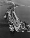
| Date: | 09 17 1948 |
|---|---|
| Description: | Aerial view of two Lake Michigan ferries tied up at harbor slips. The eastern terminus of the Green Bay Route was the Lake Michigan port city of Kewaunee. ... |
If you didn't find the material you searched for, our Library Reference Staff can help.
Call our reference desk at 608-264-6535 or email us at: