 Filter: Categories of Wisconsin Historical Images
Filter: Subject of Industrial buildings
Filter: Subject of transportation
Filter: Subject of fields (agriculture)
Filter: Categories of Wisconsin Historical Images
Filter: Subject of Industrial buildings
Filter: Subject of transportation
Filter: Subject of fields (agriculture)
| Date: | 06 21 1930 |
|---|---|
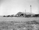
| Description: | Midwest Air Transport planes in front of the hangar at the Madison Airport. Located northeast of the city near the Oscar Mayer plant, the field was someti... |
| Date: | 11 13 1909 |
|---|---|
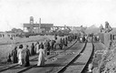
| Description: | Photographic postcard of an elevated view of people walking to the mine (in the distance) after a disaster. Caption reads: "Scene at Mine Disaster, Cherry,... |
| Date: | 1928 |
|---|---|
| Description: | The Tri City Airport which served Wisconsin Rapids, Port Edwards, and Nekoosa, was organized in 1928 after the Nekoosa-Edwards Paper Company decided to pur... |
| Date: | 1923 |
|---|---|
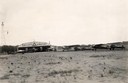
| Description: | The hangar and three airplanes (a Canuck and a J-1 Standard) at the airport operated by the Larson Brothers of Larsen, Wisconsin. The field was both the mo... |

| Date: | 1874 |
|---|---|
| Description: | Bird's-eye map of Chippewa Falls. |
| Date: | 05 26 1932 |
|---|---|
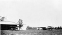
| Description: | At Royal Airport, a line of airplanes are parked in a row in a field. In the background is a hangar with automobiles parked nearby. |

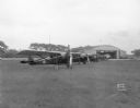
| Date: | 06 14 1930 |
|---|---|
| Description: | View from building towards five airplanes, parked in a line outdoors, at Madison Airport, Coolidge Avenue between North Street and Kedzie Street. |
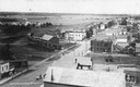
| Date: | 1907 |
|---|---|
| Description: | Elevated view of Cameron. Rooftops are in the foreground, and an unpaved street is along the left. Railroad tracks cut across the street, with railroad car... |

| Date: | 10 1928 |
|---|---|
| Description: | Aerial view of Sun Prairie, including the central business district, residences, and the surrounding countryside stretching to the horizon. |
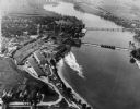
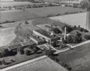
| Date: | 1948 |
|---|---|
| Description: | Aerial view of the Kimberly-Clark Paper Mill on the Fox River, just east of Appleton. |
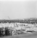
| Date: | 1912 |
|---|---|
| Description: | Winter view over fields of town with hills in the far background. |
| Date: | 07 1949 |
|---|---|
| Description: | Aerial view of the Carnation Company milk condensery. |

| Date: | |
|---|---|
| Description: | Next to a billboard, a road cuts through a field of petroleum derricks. |

| Date: | 1920 |
|---|---|
| Description: | A vast oil field displays how Oklahoma became the the largest oil-producer in the country. Caption reads: "Oil Fields near Tulsa, Okla." |

| Date: | 1917 |
|---|---|
| Description: | Elevated view of five children walking in a field behind what appears to be tenement housing. Wooden fire escapes are attached to the rear of the buildings... |
| Date: | |
|---|---|
| Description: | A view down Main Street. Shops are on either side of the street. Farmer's Bank is down the hill on the right. |
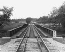
| Date: | 1929 |
|---|---|
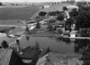
| Description: | View down the railroad tracks across the bridge. On the far side are barns and industrial buildings among trees. |
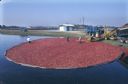
| Date: | 1997 |
|---|---|
| Description: | Elevated view of harvesters wading through cranberries contained by booms to feed them onto a conveyor to be loaded into the waiting trucks. |
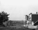
| Date: | 1966 |
|---|---|
| Description: | "This view is from St. Theresa Catholic Church. Looking north toward Zimmel Implement." |
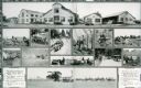
| Date: | 1920 |
|---|---|
| Description: | Two-page advertisement featuring a collage of photographs depicting the Yuba ball tread tractor at work in farm fields. A photograph of the Yuba Constructi... |
If you didn't find the material you searched for, our Library Reference Staff can help.
Call our reference desk at 608-264-6535 or email us at: