 Filter: Categories of Wisconsin Historical Images
Filter: Subject of Indian reservations
Filter: Subject of service industries
Filter: Categories of Wisconsin Historical Images
Filter: Subject of Indian reservations
Filter: Subject of service industries
| Date: | |
|---|---|
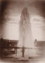
| Description: | Water gushes 18 feet in the air from a 6-inch pipe at the Lower Brule Agency. A man stands behind the pipe on the right. |
| Date: | |
|---|---|
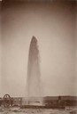
| Description: | Water gushes 60 feet in the air from a 4-inch pipe at the Lower Brule Agency. Two men stand on the left near pumping machinery. |

| Date: | 1937 |
|---|---|
| Description: | This map shows the Wisconsin Conservation Department forest protection divisions and the locations of state forests, national forests, Indian reservations,... |

| Date: | 05 01 1938 |
|---|---|
| Description: | This map shows the locations of Wisconsin Conservation Department forest protection districts and cooperative areas, state forests, national forests, India... |

| Date: | 1950 |
|---|---|
| Description: | This road map shows federal, state and county roads in Wisconsin, northern Illinois, northeastern Iowa, eastern Minnesota, and the western portion of Michi... |

| Date: | 1952 |
|---|---|
| Description: | This map shows counties, towns, cities, and selected villages, as well as the Menominee Indian Reservation are identified on this U.S. Post Office. Circles... |

| Date: | |
|---|---|
| Description: | A map of Iron County, Wisconsin, shows color-coded townships, sections, lakes and streams, villages, railroads, roads, tourist camps, and La Pointe and Lac... |

| Date: | 1974 |
|---|---|
| Description: | This 1968 map identifies resorts in the Lac du Flambeau Indian Reservation region of Wisconsin, covering parts of Iron, Vilas, Oneida, and Price counties. ... |

| Date: | 1896 |
|---|---|
| Description: | This map of Brown County, Wisconsin, from the late 19th century shows land claims along the Fox River, the township and range grid, towns, sections, cities... |

| Date: | 1909 |
|---|---|
| Description: | This 1909 map of northern Wisconsin and a portion of Michigan's Upper Peninsula shows the Lac du Flambeau Indian Reservation, cities and villages, railroad... |

| Date: | 1939 |
|---|---|
| Description: | This illustrated map shows counties, highways, rivers, roads, present and proposed state parks and forests, proposed state parkways, proposed state monumen... |

| Date: | 1853 |
|---|---|
| Description: | This map shows camps, forts, logging camps, lakes, roads, railroads, the Wisconsin River, and Lac Du Flambeau Indian Reservation. Some points of interest a... |

| Date: | 1935 |
|---|---|
| Description: | This map shows railroads, telephone lines, roads, trails, schools, sub-agency, lookout stations, churches, community centers, and school site and farm. Bil... |

| Date: | 1994 |
|---|---|
| Description: | This map shows historical sites, picnic grounds, public boat landings, canoe and motor boat trips, and resort locations. The left margin of the map include... |

| Date: | 1967 |
|---|---|
| Description: | This colored map published by the State Historical Society of Wisconsin shows key points of interest telling the story of Wisconsin's earliest settlement a... |

| Date: | 1972 |
|---|---|
| Description: | This colored map displays Wisconsin and bordering areas of Iowa, Minnesota, and Michigan. There is color-coding on the map to indicate National Forests, an... |

| Date: | 1971 |
|---|---|
| Description: | This colored map displays Wisconsin and bordering areas of Iowa, Minnesota, and Michigan. There is color-coding on the map to indicate National Forests, an... |

| Date: | 1973 |
|---|---|
| Description: | This colored map displays Wisconsin and bordering areas of Iowa, Minnesota, and Michigan. There is color-coding on the map to indicate National Forests, a... |
| Date: | 1935 |
|---|---|
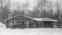
| Description: | Two men and a woman are walking from a parked automobile toward the covered porch of the Oshkosh Trading Post, a low, log building on the Menominee Indian ... |
If you didn't find the material you searched for, our Library Reference Staff can help.
Call our reference desk at 608-264-6535 or email us at: