 Filter: Categories of Wisconsin Historical Images
Filter: Subject of Hotels
Filter: Year of 1800-1899
Filter: Categories of Wisconsin Historical Images
Filter: Subject of Hotels
Filter: Year of 1800-1899
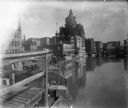
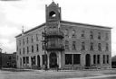
| Date: | 1898 |
|---|---|
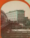
| Description: | View from pier or dock of buildings along the Milwaukee River, including a building with a clock tower. Signage on brick exteriors reads "J.C. Iverson Co. ... |

| Date: | 1896 |
|---|---|
| Description: | A map of the Chain-O-Lakes in Waupaca, including Indian trails. The path of the Waupaca Electric Railway from the Grand View Hotel to the Wisconsin Central... |
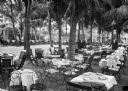
| Date: | 1893 |
|---|---|
| Description: | A view of an outdoor seating area at Royal Poinciana Hotel. Numerous tables are arranged around the perimeter of a courtyard, each set with a tablecloth, p... |
| Date: | 1898 |
|---|---|
| Description: | Exterior view of the Seaside Inn. Automobiles are parked on the streets alongside the hotel and individuals sit on benches and walk nearby. |
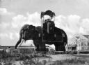
| Date: | 1882 |
|---|---|
| Description: | A view of the left side of the Elephant Hotel, constructed in the shape of an elephant with small windows punctuating the side and a covered open-air obser... |

| Date: | 1878 |
|---|---|
| Description: | Elevated view of the Ocean House hotel with men, women, and children posing in front of it. Another group of people are standing on the third story balcony... |
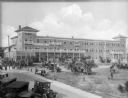
| Date: | 1872 |
|---|---|
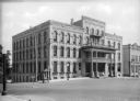
| Description: | View across street toward the hotel, at 100 Jackson Street, built in 1872. It contains decorative brickwork around all street-side windows and on the pedim... |

| Date: | 1870 |
|---|---|
| Description: | View across water toward the back side of a railroad station and outbuilding that face the creek. A hotel, garage, and homes are around the structure. |
| Date: | 1869 |
|---|---|
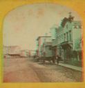
| Description: | Stereograph of the Axtell House building, with a storefront next to it advertising "Clothing Hats Caps Sailors Outfits". A bridge is on the left and a man... |

| Date: | 1870 |
|---|---|
| Description: | Stereograph looking south from the post office at the corner of Mifflin Street and Wisconsin Avenue across one corner of the Capitol Square toward Grace Ep... |

| Date: | 1860 |
|---|---|
| Description: | Stereograph of the Townsend House boathouse across a lake. |
| Date: | 1870 |
|---|---|
| Description: | Stereograph of New Richmond(?) during a fourth of July celebration. Identification has not been fully verified, but there was a Coombs Hotel in this town a... |
| Date: | 1871 |
|---|---|
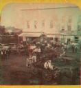
| Description: | A stereograph of the town square and Main Street. The three-story building visible in the center of the photograph was operated as the National Hotel. It w... |
| Date: | 1899 |
|---|---|
| Description: | View of Hotel Hutchinson, situated at the corner of two streets. The entrance stands beneath a bell tower and a group of boys, some with bicycles, stands n... |
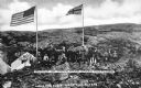
| Date: | 07 05 1899 |
|---|---|
| Description: | View of a tourist group at White Pass, a mountain pass located between Alaska and Canada. A shack has a sign that reads: "U.S. Hotel Restaurant" is to the ... |
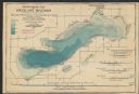
| Date: | 1898 |
|---|---|
| Description: | A hydrographic map of Green Lake, Geneva, Wisconsin, and includes 5 cross sections of the depths at various points as well as along a line running the leng... |

| Date: | 1870 |
|---|---|
| Description: | A map of Iowa County, Wisconsin mounted on cloth that shows the villages of Avoca, Mifflin, Linden, Arena, Helena Station, Highland, Dodgeville, as well as... |
| Date: | 1898 |
|---|---|
| Description: | This map shows the contour depths of Lake Beulah, Booth Lake, and Army Lake (labeled East Troy Lake on the map) in Walworth County, Wisconsin, and includes... |

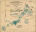
| Date: | 1898 |
|---|---|
| Description: | This map shows the contour depths of Delavan Lake and the Lauderdale Lakes in Walworth County, Wisconsin, and includes nine cross sections of the lakes. Ro... |

| Date: | 1898 |
|---|---|
| Description: | This map shows the contour depths of Elkhart Lake in the Town of Rhine, Sheboygan County, Wisconsin, and includes two cross sections of the lake. The villa... |
If you didn't find the material you searched for, our Library Reference Staff can help.
Call our reference desk at 608-264-6535 or email us at: