Filter: Categories of Wisconsin Historical Images
Filter: Subject of Hotels
Filter: Subject of transportation
Filter: County of Walworth
Filter: Categories of Wisconsin Historical Images
Filter: Subject of Hotels
Filter: Subject of transportation
Filter: County of Walworth

| Date: | 1882 |
|---|---|
| Description: | Bird's-eye map of Lake Geneva, looking southwest, with insets of points of interest. |
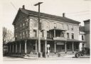
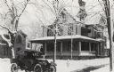
| Date: | 05 16 1932 |
|---|---|
| Description: | View from street towards the hotel. In front on the terrace is a telephone pole and a lamppost, and on the right is a parked truck. One sign on the hotel r... |
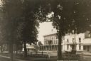
| Date: | |
|---|---|
| Description: | View of the hotel from across the street through trees and a fence. The hotel was later called the Cobblestone Inn. A small building on the left near the h... |
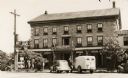
| Date: | 1940 |
|---|---|
| Description: | View across street towards the inn, with three cars parked in front. There is a "Chicken & Steak Dinner" sign, as well as a "Schlitz" beer sign. The cobbl... |
| Date: | 1895 |
|---|---|
| Description: | View from road of the Buena Vista House. There is a utility pole in front with many wires attached. This Greek revival inn was erected in 1843 by Samuel R.... |
| Date: | 1909 |
|---|---|
| Description: | View of the exterior of the Buena Vista House, a hotel located in East Troy. This Greek revival inn was erected in 1843 by Samuel R Bradley of Milwaukee, w... |
| Date: | 1895 |
|---|---|
| Description: | View of the Buena Vista House with electric power lines. This Greek revival inn was erected in 1843 by Samuel R. Bradley of Milwaukee, who is said to have ... |
| Date: | 1905 |
|---|---|
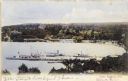
| Description: | Elevated view of Lake Geneva Bay, with assorted homes and hotels, and boats docked at long piers. Caption reads: "Geneva Bay, Lake Geneva, Wis." |
| Date: | |
|---|---|
| Description: | Exterior view of the Seven Gables Inn with a parked car in the foreground. |
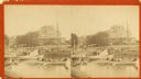
| Date: | 1880 |
|---|---|
| Description: | Stereograph view of the Whiting House with its large harbor and boats. Whiting House is a four-story wood frame Second Empire style hotel standing on the l... |
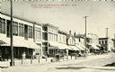
| Date: | 1905 |
|---|---|
| Description: | View towards the left side of the street, with horse-drawn vehicles along the curb. The Hotel Sharon is in the center among the line of storefronts. Captio... |
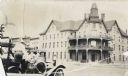
| Date: | |
|---|---|
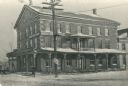
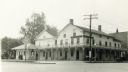
| Description: | View from street of hotel with balcony above entrance on corner, and a clock tower. Motorcar with several people are on the left. |
| Date: | 07 1925 |
|---|---|
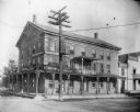
| Description: | This substantial wooden hotel in the classical revival style has a large wing in the rear and another on the right. A wrap-around porch unifies the buildin... |
| Date: | 1898 |
|---|---|
| Description: | This map shows the contour depths of Lake Beulah, Booth Lake, and Army Lake (labeled East Troy Lake on the map) in Walworth County, Wisconsin, and includes... |

| Date: | 1898 |
|---|---|
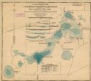
| Description: | This map shows the contour depths of Delavan Lake and the Lauderdale Lakes in Walworth County, Wisconsin, and includes nine cross sections of the lakes. Ro... |

| Date: | 1930 |
|---|---|
| Description: | Shows roads, fire stations, golf course, and accommodations around Delavan Lake. "The drive around the lake is divided into zones from 0 to 900 as shown. P... |
| Date: | 08 24 1882 |
|---|---|
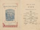
| Description: | Front cover and menu page from Kaye's Park House, with a lakeside view of the hotel, a paddlewheel steamboat, people in rowboats or standing by a Kaye's Pa... |

| Date: | 1959 |
|---|---|
| Description: | This map of Lake Geneva has relief shown by contours and water depths shown by isolines. The map includes an index of schools, churches, public services, i... |

| Date: | 1858 |
|---|---|
| Description: | This map is hand-colored and mounted on cloth and shows lot and block numbers and dimensions, landownership, streets, railroads, selected buildings, fair g... |
If you didn't find the material you searched for, our Library Reference Staff can help.
Call our reference desk at 608-264-6535 or email us at: