 Filter: Categories of Wisconsin Historical Images
Filter: Subject of Hotels
Filter: Subject of michigan, lake
Filter: Categories of Wisconsin Historical Images
Filter: Subject of Hotels
Filter: Subject of michigan, lake

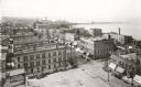
| Date: | 1898 |
|---|---|
| Description: | Bird's-eye map of Milwaukee with prominent streets and buildings identified. Taken from City Hall Tower. |
| Date: | 1898 |
|---|---|
| Description: | Elevated view of the downtown area looking northeast from the courthouse corner. |
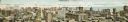
| Date: | 1910 |
|---|---|
| Description: | Panoramic bird's-eye view of the heart of the Loop. Labeled sites include: Insurance Exchange, Continental and Commercial National Bank, Post Office, Dear... |

| Date: | 1950 |
|---|---|
| Description: | This road map shows federal, state and county roads in Wisconsin, northern Illinois, northeastern Iowa, eastern Minnesota, and the western portion of Michi... |
| Date: | 07 1923 |
|---|---|
| Description: | View of Mackinac Island from a boat offshore. There are two large wooden piers with warehouses, and a beach on the right. Commercial buildings line the wat... |
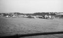
| Date: | 02 1925 |
|---|---|
| Description: | There is smoke damage to the bricks evident above the windows of the company store in this view of the ghost town of Fayette. To the right, with dormers, i... |
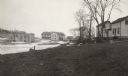
| Date: | 02 1925 |
|---|---|
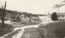
| Description: | Abandoned workers' houses stand along the shore of Lake Michigan. The Fayette Tourists Lodge is on the far left. |
| Date: | 1915 |
|---|---|
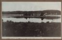
| Description: | View of Fish Creek from Weborg's Point in Peninsula State Park. The Fish Creek dock with barnlike warehouse is in center right. Behind the dock is the two-... |
| Date: | 1915 |
|---|---|
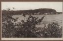
| Description: | Hen Island is reflected in the water of Fish Creek Bay in this view from Nelson Point in Peninsula State Park. The homes and businesses of Fish Creek are i... |
| Date: | 1915 |
|---|---|
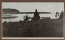
| Description: | View down hill towards a man fishing from the pier at Nelson Point in Peninsula State Park. Fish Creek is seen across the bay. Dr. Welcker's Casino is the ... |

| Date: | 1869 |
|---|---|
| Description: | This map was engraved from original drawings and surveys taken by Louis Lipman. Includes Milwaukee street directory on the left hand side. Bottom right cor... |

| Date: | 1891 |
|---|---|
| Description: | This maps has an index of depots, hotels, prominent institutions and buildings, churches, and places of amusement. The map was removed from an unidentified... |
| Date: | 02 22 1892 |
|---|---|
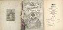
| Description: | Back cover, front cover, and menu page for the Old Settlers' Club of Milwaukee County annual banquet. The back page includes an illustration of a monument ... |
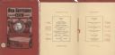
| Date: | 02 22 1902 |
|---|---|
| Description: | Front cover and menu page of the annual banquet of the Old Settlers' Club of Milwaukee County. On the cover is an oval tipped-in portrait of club president... |

| Date: | 1956 |
|---|---|
| Description: | Intended for tourists, this brochure features a map of Milwaukee's central business district as well as general information about parking, beaches and othe... |

| Date: | 1926 |
|---|---|
| Description: | This brochure was intended for tourists and shows resorts, lakes and railroads in northwestern Wisconsin and part of Michigan’s upper peninsula. Also inclu... |

| Date: | 1939 |
|---|---|
| Description: | This brochure was intended for tourists and shows resorts, lakes and railroads in northwestern Wisconsin and part of Michigan’s upper peninsula. Also inclu... |

| Date: | 1942 |
|---|---|
| Description: | This map shows the route of the Milwaukee Road, roads, foot trails, resorts, and ranger stations. The map includes text, illustrations, a railroad fare tab... |

| Date: | 1937 |
|---|---|
| Description: | This map shows the major cities, towns, highways, roads, lakes, and rivers of Wisconsin and some of the neighboring states. An index is included on the fro... |

| Date: | 1921 |
|---|---|
| Description: | This map shows in red the NorthWestern Railway Line routes running from Chicago, Illinois to northern Wisconsin and Michigan. The map includes cities and t... |
If you didn't find the material you searched for, our Library Reference Staff can help.
Call our reference desk at 608-264-6535 or email us at: