 Filter: Categories of Wisconsin Historical Images
Filter: Subject of Hospitals
Filter: Subject of water
Filter: Categories of Wisconsin Historical Images
Filter: Subject of Hospitals
Filter: Subject of water

| Date: | 1842 |
|---|---|
| Description: | This hand-colored lithograph of the second Fort Howard, with Indians canoeing on the Fox River, shows the hospital built 1834-1835 outside the stockade on ... |
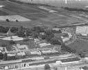
| Date: | 1958 |
|---|---|
| Description: | Aerial photograph showing the J.S. Timlin Lumber Company, 2702 University Avenue, as well as Doctors Park, the Veterans Hospital, and the First Unitarian S... |

| Date: | 1950 |
|---|---|
| Description: | Aerial view of the Frank Lloyd-Wright-dsigned Unitarian Church under construction and the Veteran's Administration Hospital, also under construction, to th... |

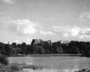
| Date: | |
|---|---|
| Description: | Elevated view of the Lake Monona shoreline and downtown Madison taken from the Farwell Octagon House (Harvey Hospital/Soldier's Orphans Home). |
| Date: | |
|---|---|
| Description: | Aerial view of the hospital along the banks of a river, with a bridge on the far left. Beyond the river is a baseball park. On the back of the card is writ... |
| Date: | 1945 |
|---|---|
| Description: | View of the Wausau Memorial Hospital, with the Wisconsin River in the foreground. |
| Date: | 1910 |
|---|---|
| Description: | View of the outdoor landscape as seen from a window in the Stoughton Hospital, along with an inset of the building in the upper left corner. Caption reads:... |

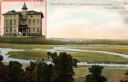
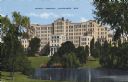
| Date: | |
|---|---|
| Description: | Slightly elevated view of the Methodist Hospital. A lake is in the background. Caption reads: "The Methodist Hospital, Madison, Wisconsin". |
| Date: | 07 27 1944 |
|---|---|
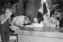
| Description: | Childern attending a speech training class at the Wisconsin Orthopedic Cleft Palate Clinic. The clinic is sponsored by the Bureau for Handicapped Children ... |
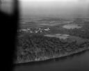
| Date: | 10 10 1947 |
|---|---|
| Description: | Aerial view of the Wisconsin Memorial Hospital run by the Veterans Administration on the north shore of Lake Mendota on the grounds of the Mendota State Ho... |

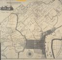
| Date: | 1919 |
|---|---|
| Description: | This is a collection of three hand-colored plat maps. One map is a plat plan and includes annotations and an index that shows public land, business, indust... |

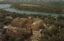
| Date: | 1928 |
|---|---|
| Description: | An aerial view of the buildings and grounds of the Wisconsin Memorial Hospital, located at Farwell's Point. |

| Date: | 1883 |
|---|---|
| Description: | Caption on reverse side of stereograph reads, "Governmental buildings, Wisconsin Conservatory of Music and Hospital over Lake Mendota-looking from Capitol ... |
| Date: | 1943 |
|---|---|
| Description: | The hospital entrance is behind a small pond that is surrounded by trees and a landscaped lawn. Caption reads: "County Hospital, Milwaukee, Wis." |
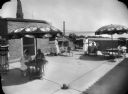
| Date: | 1930 |
|---|---|
| Description: | Sunroof of the Methodist Hospital, showing patients, nurses, and a view of Lake Monona in the background. |
| Date: | |
|---|---|
| Description: | Detail of Philadelphia including an illustration of the Pennsylvania Hospital and the Schuykill River. |

| Date: | 1883 |
|---|---|
| Description: | Caption on reverse side of stereograph reads: "Governmental buildings, Wisconsin Conservatory of Music and Hospital over Lake Mendota-looking from Capitol ... |

| Date: | 10 18 1952 |
|---|---|
| Description: | Aerial view of Madison General Hospital and the surrounding Greenbush and Vilas neighborhoods. Also visible is Monona Bay with Camp Randall and Picnic Poi... |
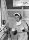
| Date: | 03 1945 |
|---|---|
| Description: | United States Army nurse, Ann T. Hyland, is washing her hands in the 148th General Hospital's scrub room. Hyland is wearing a white cloth around her hair, ... |

| Date: | 1976 |
|---|---|
| Description: | A street map of Milwaukee County, Wisconsin that identifies the location of schools, hospitals, parks, beaches, streets, freeways, both planned or under co... |
If you didn't find the material you searched for, our Library Reference Staff can help.
Call our reference desk at 608-264-6535 or email us at: