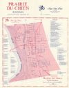
| Date: | 1919 |
|---|---|
| Description: | This is a collection of three hand-colored plat maps. One map is a plat plan and includes annotations and an index that shows public land, business, indust... |

| Date: | |
|---|---|
| Description: | A hand-drawn map of Camp Curtis which was prepared for Colonel R. McMurphy. |

| Date: | 1888 |
|---|---|
| Description: | This map has relief shown by hachures and features inset maps of a plat of E.D. Clinton and Blackwell’s add’n to the City of La Crosse. Wards (1-10) shaded... |

| Date: | 04 1905 |
|---|---|
| Description: | Map of the Madison, Wisconsin region showing the four major lakes, starting in the north with Lake Mendota, Lake Monona, Lake Waubesa, and Lake Kegonsa. La... |

| Date: | 1976 |
|---|---|
| Description: | This map includes an index of streets, government and historic buildings, hospitals, schools, places of recreation, churches, cemeteries, and other miscell... |

| Date: | 1893 |
|---|---|
| Description: | This map shows wards, railroads, street cars, streets, lot and block numbers, landownership, parks, hospitals, the Sheboygan River, and Lake Michigan. Ward... |

| Date: | 1915 |
|---|---|
| Description: | This map shows wards, railroads, street railways, streets, lot and block numbers, parks, and hospitals. Also included are manuscript annotations of points ... |

| Date: | 1956 |
|---|---|
| Description: | This map shows local streets, roads, railroads, highways, parks, cemeteries, hospitals, the University of Wisconsin, Middleton, Maple Bluff, Shorewood Hill... |

| Date: | 2008 |
|---|---|
| Description: | This double sided map shows roads, railroads, biking trails, civil townships, parks, wildlife refuges, town halls, and hospitals. The region map covers par... |

| Date: | 1904 |
|---|---|
| Description: | Map showing lots, additions, and wards within the city limits, as well as some landownership. The streets are labeled, as is Lake Winnebago, rivers, railro... |

| Date: | 1967 |
|---|---|
| Description: | Air view looking north toward Lake Mendota. The intersection of West Washington Ave. and S. Park Street is at bottom center. The Triangle Redevelopment Pro... |

| Date: | |
|---|---|
| Description: | Aerial view of the Greenbush neighborhood in winter partially demolished for the Triangle Redevelopment Project. Monona Bay and Brittingham park are at rig... |
If you didn't find the material you searched for, our Library Reference Staff can help.
Call our reference desk at 608-264-6535 or email us at: