Filter: Categories of Wisconsin Historical Images
Filter: Subject of Hospitals
Filter: Subject of human settlements
Filter: Year of 1800-1899
Filter: Categories of Wisconsin Historical Images
Filter: Subject of Hospitals
Filter: Subject of human settlements
Filter: Year of 1800-1899
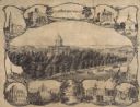
| Date: | 1864 |
|---|---|
| Description: | Bird's-eye view of Madison, with 12 vignettes and in the center is "The Capitol of Wisconsin View from the Capitol House". The buildings on the top are, fr... |

| Date: | 1895 |
|---|---|
| Description: | Dane County Asylum for the Criminally Insane. In 1880 it became a part of the county hospital system, which was set up to provide longer term care to peopl... |
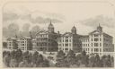
| Date: | 1874 |
|---|---|
| Description: | Wisconsin State Hospital for the Insane (Mendota Mental Health Institute) near Madison. |

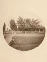
| Date: | 1883 |
|---|---|
| Description: | Caption on reverse side of stereograph reads, "Governmental buildings, Wisconsin Conservatory of Music and Hospital over Lake Mendota-looking from Capitol ... |
| Date: | 1867 |
|---|---|
| Description: | E.T. Mix designed the original building of the National Soldiers Home in 1867. At the time the structure was dedicated on 28 September 1867, the wings had ... |

| Date: | 1883 |
|---|---|
| Description: | Caption on reverse side of stereograph reads: "Governmental buildings, Wisconsin Conservatory of Music and Hospital over Lake Mendota-looking from Capitol ... |

| Date: | 1831 |
|---|---|
| Description: | Map of the city of Louisville, Kentucky on the Ohio River showing streets and numbered lots. The Ohio River, Corn Island, and the Louisville and Portland C... |

| Date: | 1888 |
|---|---|
| Description: | This map has relief shown by hachures and features inset maps of a plat of E.D. Clinton and Blackwell’s add’n to the City of La Crosse. Wards (1-10) shaded... |

| Date: | 1834 |
|---|---|
| Description: | This map is pen, ink, and pencil on paper and shows plat of the town, local streets, mills, forts, hospitals, and parts of Devil River and Fox River. |

| Date: | 1893 |
|---|---|
| Description: | This map shows wards, railroads, street cars, streets, lot and block numbers, landownership, parks, hospitals, the Sheboygan River, and Lake Michigan. Ward... |

| Date: | 1879 |
|---|---|
| Description: | This map shows asylums, cemeteries, hospitals, parks, streets, and wards. Relief is shown by contours. Also included are manuscript annotations in pencil. ... |

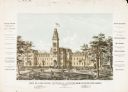
| Date: | 1885 |
|---|---|
| Description: | View of the Wisconsin Hospital for the Insane and grounds. In 1935 it became the Mendota State Hospital. It was built in 1860 by architect Stephen Vaughn S... |
If you didn't find the material you searched for, our Library Reference Staff can help.
Call our reference desk at 608-264-6535 or email us at: