 Filter: Categories of Wisconsin Historical Images
Filter: Subject of Hospitals
Filter: Subject of human settlements
Filter: Categories of Wisconsin Historical Images
Filter: Subject of Hospitals
Filter: Subject of human settlements
| Date: | 1936 |
|---|---|
| Description: | Exterior view of the hospital. A curved driveway leads up to the entrance behind a low stone wall planted with shrubs. Trees line the street. Caption reads... |

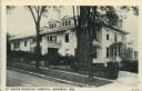
| Date: | 1914 |
|---|---|
| Description: | Photographic postcard of an exterior view from the street of a hospital with a large porch. Caption reads: "Yates Memorial Hospital, Berlin, Wis." |

| Date: | 1888 |
|---|---|
| Description: | This map has relief shown by hachures and features inset maps of a plat of E.D. Clinton and Blackwell’s add’n to the City of La Crosse. Wards (1-10) shaded... |

| Date: | 1834 |
|---|---|
| Description: | This map is pen, ink, and pencil on paper and shows plat of the town, local streets, mills, forts, hospitals, and parts of Devil River and Fox River. |

| Date: | |
|---|---|
| Description: | A woman (possibly a nurse) standing on the sidewalk in front of the sign at the entrance to Hansberry Hospital, Hillsburo's first hospital. It was establis... |

| Date: | |
|---|---|
| Description: | Three-quarter view from yard of Hansberry Hospital, Hillsburo's first hospital which was established by P.H. Hansberry in 1914. Two women stand on the left... |

| Date: | 06 14 1961 |
|---|---|
| Description: | Forty-three nursing students in the Madison General Hospital School of Nursing Class of 1963 begin the two-year clinical phase of their nursing education. ... |

| Date: | 1920 |
|---|---|
| Description: | Hand-colored postcard view of St. Joseph's Hospital. The view is facing south-west and reveals a large fenced side lawn with foot paths, plants and six peo... |

| Date: | 1920 |
|---|---|
| Description: | Color postcard view across street towards the St. Joseph's Hospital. An automobile is parked at the curb in front. Caption reads: "St. Joseph's Hospital, C... |

| Date: | 1936 |
|---|---|
| Description: | View from street towards the St. Joseph's Hospital. In the center is a two level open porch, with two people on the second level. A 1930s automobile is par... |

| Date: | 04 1905 |
|---|---|
| Description: | Map of the Madison, Wisconsin region showing the four major lakes, starting in the north with Lake Mendota, Lake Monona, Lake Waubesa, and Lake Kegonsa. La... |

| Date: | 1976 |
|---|---|
| Description: | This map includes an index of streets, government and historic buildings, hospitals, schools, places of recreation, churches, cemeteries, and other miscell... |

| Date: | 1920 |
|---|---|
| Description: | Slightly elevated photographic postcard view of the General Hospital. Caption reads: "General Hospital, Dodgeville, Wisc." |

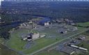
| Date: | 1910 |
|---|---|
| Description: | Aerial view of the Wisconsin Masonic Home and Farm on Highway 18, thirty miles west of Milwaukee. |

| Date: | 1930 |
|---|---|
| Description: | Black and white photographic postcard view of a large white building with awnings, labeled as the Pepin County Hospital. Caption reads: "Pepin County Hospi... |
| Date: | 1950 |
|---|---|
| Description: | Aerial view of Sacred Heart Hospital. |

| Date: | 1920 |
|---|---|
| Description: | Photographic postcard view from street of St. Joseph's Hospital. Caption reads: "St. Joseph's Hospital, Chippewa Falls, Wis." |

| Date: | 07 28 1934 |
|---|---|
| Description: | This map shows buildings and dimensions of Fort Crawford and hospital overlaid on a plat of existing lots, streets, and closed streets. |

| Date: | 1893 |
|---|---|
| Description: | This map shows wards, railroads, street cars, streets, lot and block numbers, landownership, parks, hospitals, the Sheboygan River, and Lake Michigan. Ward... |

| Date: | 1915 |
|---|---|
| Description: | This map shows wards, railroads, street railways, streets, lot and block numbers, parks, and hospitals. Also included are manuscript annotations of points ... |
If you didn't find the material you searched for, our Library Reference Staff can help.
Call our reference desk at 608-264-6535 or email us at: