 Filter: Categories of Wisconsin Historical Images
Filter: Subject of Hospitals
Filter: Subject of human settlements
Filter: Subject of land
Filter: Categories of Wisconsin Historical Images
Filter: Subject of Hospitals
Filter: Subject of human settlements
Filter: Subject of land
| Date: | 05 25 1936 |
|---|---|
| Description: | Lake View Tuberculosis Sanatorium, 1202 Northport, and nurses' dormitory. |

| Date: | 1945 |
|---|---|
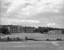
| Description: | View of the Wausau Memorial Hospital, with the Wisconsin River in the foreground. |

| Date: | 1910 |
|---|---|
| Description: | View across road towards St. Mary's Hospital. Caption reads: "St. Mary's Hospital, Watertown, Wis." |

| Date: | 1910 |
|---|---|
| Description: | View of the outdoor landscape as seen from a window in the Stoughton Hospital, along with an inset of the building in the upper left corner. Caption reads:... |

| Date: | 10 10 1947 |
|---|---|
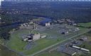
| Description: | Aerial view of the Wisconsin Memorial Hospital run by the Veterans Administration on the north shore of Lake Mendota on the grounds of the Mendota State Ho... |
| Date: | 1951 |
|---|---|
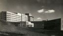
| Description: | The Veterans' Administration Hospital, located at 2500 Overlook Terrace. |

| Date: | 1943 |
|---|---|
| Description: | The hospital entrance is behind a small pond that is surrounded by trees and a landscaped lawn. Caption reads: "County Hospital, Milwaukee, Wis." |
| Date: | |
|---|---|
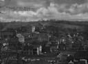
| Description: | Elevated view of the West Ward of town including the hospital. View features many large wooden buildings built on a hillside with a lumber yard in the fore... |

| Date: | |
|---|---|
| Description: | View across road toward the Shore Road Hospital. A gate stands at the edge of the property at the sidewalk and leads to stairs and the entrance of the hosp... |

| Date: | 1920 |
|---|---|
| Description: | This map produced just after Word War I shows the proposed location for a veterans' hospital in the Eau Claire-Chippewa Falls region. Highways, rail lines ... |

| Date: | 1976 |
|---|---|
| Description: | A street map of Milwaukee County, Wisconsin that identifies the location of schools, hospitals, parks, beaches, streets, freeways, both planned or under co... |

| Date: | 1993 |
|---|---|
| Description: | A map of Milwaukee County, indicating the locations of toxic sites and the types of toxic sites, ranging from those listed as a superfund site, industry re... |

| Date: | 1990 |
|---|---|
| Description: | This late 20th century tourist map of Sauk County, Wisconsin, shows the highways and roads, cities and towns, parks, airports, canoe landings, hospitals, s... |

| Date: | 1831 |
|---|---|
| Description: | Map of the city of Louisville, Kentucky on the Ohio River showing streets and numbered lots. The Ohio River, Corn Island, and the Louisville and Portland C... |

| Date: | 04 1905 |
|---|---|
| Description: | Map of the Madison, Wisconsin region showing the four major lakes, starting in the north with Lake Mendota, Lake Monona, Lake Waubesa, and Lake Kegonsa. La... |

| Date: | 1976 |
|---|---|
| Description: | This map includes an index of streets, government and historic buildings, hospitals, schools, places of recreation, churches, cemeteries, and other miscell... |

| Date: | 1910 |
|---|---|
| Description: | Aerial view of the Wisconsin Masonic Home and Farm on Highway 18, thirty miles west of Milwaukee. |
| Date: | 1950 |
|---|---|
| Description: | Aerial view of Sacred Heart Hospital. |

| Date: | 07 28 1934 |
|---|---|
| Description: | This map shows buildings and dimensions of Fort Crawford and hospital overlaid on a plat of existing lots, streets, and closed streets. |

| Date: | 1760 |
|---|---|
| Description: | Map showing upstate New York, Lake Ontario, and the St. Lawrence River during the last, decisive battle of the French and Indian War. The main map shows a ... |
If you didn't find the material you searched for, our Library Reference Staff can help.
Call our reference desk at 608-264-6535 or email us at: