 Filter: Categories of Wisconsin Historical Images
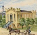
Filter: Subject of Horse-drawn vehicles
Filter: Subject of church buildings
Filter: Categories of Wisconsin Historical Images
Filter: Subject of Horse-drawn vehicles
Filter: Subject of church buildings
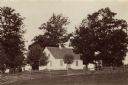
| Date: | 1890 |
|---|---|
| Description: | Site of the Battle to Antietam, The Dunker Church. A group of men stand among trees on the left. Horse-drawn carriages are under trees on the right. |
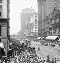
| Date: | |
|---|---|
| Description: | Elevated view of crowd along sidewalks on State Street, and the Masonic Temple from Madison Street. Streetcars and horse-drawn vehicles are in the street. |
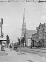
| Date: | |
|---|---|
| Description: | View down Grand Avenue from 6th Street. On the street are several horse-drawn vehicles. There is a church in the background. |
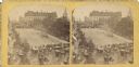
| Date: | 07 04 1876 |
|---|---|
| Description: | Stereograph of view of procession, military company and citizens at Great Centennial Day at the Capitol Square. Scene at Main and Carroll Streets showing t... |

| Date: | 1882 |
|---|---|
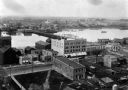
| Description: | Bird's-eye views of various sections of Milwaukee. |

| Date: | 1878 |
|---|---|
| Description: | Bird's-eye map of Chilton with insets of points of interest, including P.H. Becker's Brewery, Chilton House, and Gutheil's Block. |

| Date: | 1880 |
|---|---|
| Description: | Bird's-eye map over the Mississippi River of Fountain City. Paddle steamers and steamboats are on the river, and bluffs are in the background. |

| Date: | 1881 |
|---|---|
| Description: | Bird's-eye map of Milton Junction. |
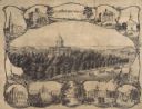
| Date: | 1864 |
|---|---|
| Description: | Bird's-eye view of Madison, with 12 vignettes and in the center is "The Capitol of Wisconsin View from the Capitol House". The buildings on the top are, fr... |

| Date: | 1875 |
|---|---|
| Description: | Bird's-eye map after a fire destroyed a large area of the town. In memory of the Great Conflagration on April 28th, 1875. Taken from the North-Side. |

| Date: | 1883 |
|---|---|
| Description: | Bird's-eye map of Prairie du Sac, Wisconsin with an inset of Clifton. |

| Date: | 1879 |
|---|---|
| Description: | Bird's-eye view of Viroqua, county seat of Vernon County. |

| Date: | 1858 |
|---|---|
| Description: | Elevated view from bluff looking down on city, with Lake Michigan in background. Detailed foreground with two boys playing with a grounded kite, while a ma... |

| Date: | 1854 |
|---|---|
| Description: | Bird's-eye view of Milwaukee looking east toward Lake Michigan from a bluff, long since graded into a slope, at about 6th Street between Wisconsin Avenue a... |

| Date: | 1937 |
|---|---|
| Description: | Bird's-eye view of Milwaukee in 1853 details building features and city layout from southwest. Important buildings are numbered in a silhouette drawing bel... |

| Date: | 1902 |
|---|---|
| Description: | Madison fire fighters with a hose wagon near the intersection of Webster Street and East Washington Avenue. |
| Date: | 1858 |
|---|---|
| Description: | A view of the Synagogue with a one-horse carriage in the foreground. Hölzlhuber occupied the position of organist and choirmaster for this congregation unt... |
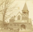
| Date: | 1894 |
|---|---|
| Description: | View of the German Methodist Church with George Bowers, a milkman, standing in the foreground. |
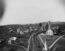
| Date: | 1885 |
|---|---|
| Description: | Elevated view looking west from the Jackson County Courthouse. |
| Date: | 1889 |
|---|---|
| Description: | Elevated view of Washington Street and the Fox River and buildings nearby. |
If you didn't find the material you searched for, our Library Reference Staff can help.
Call our reference desk at 608-264-6535 or email us at: