 Filter: Categories of Wisconsin Historical Images
Filter: Subject of Historic sites
Filter: Creator Name of Unknown
Filter: Categories of Wisconsin Historical Images
Filter: Subject of Historic sites
Filter: Creator Name of Unknown
| Date: | |
|---|---|
| Description: | This map shows the locations of historic sites and points of interest in Rusk County, Wisconsin. A location key, descriptions of the historical importance ... |

| Date: | 1960 |
|---|---|
| Description: | This mid-20th century tourist brochure for Bayfield County, Wisconsin, includes a map of the county showing towns, cities and villages, highways and roads,... |

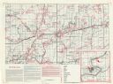
| Date: | 1975 |
|---|---|
| Description: | This 1975 road map of Columbia County, Wisconsin, shows the location of historic sites in the county but lacks a key to those sites. It includes an inset m... |
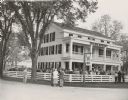
| Date: | 06 06 1953 |
|---|---|
| Description: | The official opening of Wade House. Amid great fanfare, complete with an appearance by poet Carl Sandburg, Wade House opened to the public on June 6th, 195... |
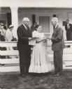
| Date: | 06 06 1953 |
|---|---|
| Description: | Ruth DeYoung Kohler II, presents the key to Wade House to Dr. William McKern, of the Wisconsin State Historical Society. The century-old stagecoach inn and... |
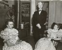
| Date: | 06 06 1953 |
|---|---|
| Description: | Carl Sandburg posing with two of the guides at Wade house during his visit to the restored stagecoach inn for its dedication as a historic site. Speaking a... |

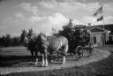
| Date: | 08 1959 |
|---|---|
| Description: | Visitors enjoy a stagecoach ride, an attraction at Old Wade House during the August "twilight tours" of this historic site. A team of two horses stand in t... |
| Date: | 07 05 1968 |
|---|---|
| Description: | Grand opening of the Wesley W. Jung Carriage Museum. A stagecoach is pulled by horses from the Jung Carriage Museum at Wade House along a curved gravel dri... |
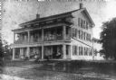
| Date: | 1920 |
|---|---|
| Description: | View from road of the exterior of Wade House. Children and adults are posing sitting and standing on the porch and balcony. |

| Date: | 1967 |
|---|---|
| Description: | This map of Cedarburg includes a list of historic buildings in the left margin. The map was created by the Ozaukee County Historical Society for Cedarburg'... |

| Date: | 1905 |
|---|---|
| Description: | Elevated view looking over Camp Randall to the University of Wisconsin campus taken from a home at 216 Campbell Street. Seen are Hiram Smith Hall, Dean Hen... |

| Date: | 1950 |
|---|---|
| Description: | Wisconsin Historical Marker near Trout Lake. The marker recognizes the first ever forest patrol flight. The marker text reads: "FIRST FOREST PATROL FLI... |
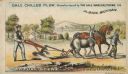
| Date: | 1878 |
|---|---|
| Description: | Front of advertising card featuring a color illustration of a man using a Gale Chilled Plow (Albion, Michigan) with a donkey in a field. Another man is wal... |
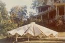
| Date: | 03 1973 |
|---|---|
| Description: | A new roof for the tower of the main house at Black Point stands on the lawn in front of the house. The roof, of an ultra-modern design, rests on a short s... |
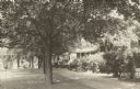
| Date: | 1940 |
|---|---|
| Description: | A row of maple trees lines the brick walkway along the main house at Black Point. There are benches on the lawn; Geneva Lake is in the background. A gable ... |
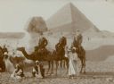
| Date: | 01 1909 |
|---|---|
| Description: | Three men in western dress riding camels pose with their Egyptian guides in front of the Sphinx at the Giza necropolis, with the Cheops pyramid in the back... |

| Date: | |
|---|---|
| Description: | This is number four in Stanley Hanks' collection of four prints of the Keystone House in Shorewood. This is the historical marker erected in 1972 by the Da... |

| Date: | 1970 |
|---|---|
| Description: | This photocopy map shows the locations of historic buildings, as well as all other buildings in the isthmus. The map also includes photographs of selected ... |

| Date: | 1930 |
|---|---|
| Description: | View of a sign identifying the Spirit Rock, which is a large boulder surrounded by sturdy protective posts. There are tree stumps in the foreground and a w... |

| Date: | 10 05 1951 |
|---|---|
| Description: | Governor Walter J. Kohler Jr., (left) and James R. Law, state highway commission chairman, standing indoors with the Peshtigo cemetery marker. The marker w... |
If you didn't find the material you searched for, our Library Reference Staff can help.
Call our reference desk at 608-264-6535 or email us at: