 Filter: Categories of Wisconsin Historical Images
Filter: Subject of Historic sites
Filter: Creator Name of Unknown
Filter: Subject of roads
Filter: Categories of Wisconsin Historical Images
Filter: Subject of Historic sites
Filter: Creator Name of Unknown
Filter: Subject of roads
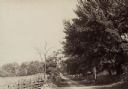
| Date: | 1890 |
|---|---|
| Description: | Hagerstown Pike. A brick wall and trees are along the road on the right. |
| Date: | 1915 |
|---|---|
| Description: | View of the Chicago Stageroad marker erected by the local Daughters of the American Revolution. |
| Date: | |
|---|---|
| Description: | Fort Crawford Hospital. A historic marker is on the lawn in front. |
| Date: | 1910 |
|---|---|
| Description: | A view of the Jacques Marquette and Louis Joliet marker. "This tablet marks the place near which Jacques Marquette and Louis Joliet entered the Wisconsin R... |

| Date: | |
|---|---|
| Description: | A view of the replica of the first house on Revolutionary Burial Hill. |
| Date: | |
|---|---|
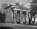
| Description: | View across street toward the Jefferson Davis mansion. Caption reads: "Jefferson Davis Mansion, now Confederate Museum." |
| Date: | |
|---|---|
| Description: | A view of 'Secession Hill', where the first secession meeting was held in November of 1860. Caption reads: "'Secession Hill' Abbeville, S.C." |
| Date: | |
|---|---|
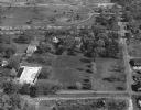
| Description: | The Villa Louis, also known as Dousman Mansion, in an aerial view. |
| Date: | |
|---|---|
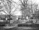
| Description: | View of Inner Line Drive at Gulph Road. Canons line the left side of the road and a reconstructed cabin stands on the right. |
| Date: | |
|---|---|
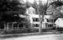
| Description: | Exterior of Wayside, the residence of Nathaniel Hawthorne, partially obscured by foliage. |

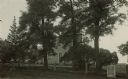
| Date: | |
|---|---|
| Description: | View of Wistaria Lodge, an early American residence, built in 1733. Also known as the Caleb Gardner House, the building features a central entrance and ch... |

| Date: | 1990 |
|---|---|
| Description: | A tourist map of Lafayette County, Wisconsin, that shows the locations of motels, camping, municipal parks, cheese factory tours, waysides, and golf course... |

| Date: | 1961 |
|---|---|
| Description: | This 1961 map of Ozaukee County, Wisconsin, identifies historic sites and landmarks in the county. Cities and villages, roads, and lakes and streams are al... |
| Date: | |
|---|---|
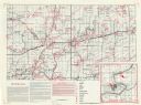
| Description: | This map shows the locations of historic sites and points of interest in Rusk County, Wisconsin. A location key, descriptions of the historical importance ... |

| Date: | 1960 |
|---|---|
| Description: | This mid-20th century tourist brochure for Bayfield County, Wisconsin, includes a map of the county showing towns, cities and villages, highways and roads,... |
| Date: | 06 06 1953 |
|---|---|
| Description: | The official opening of Wade House. Amid great fanfare, complete with an appearance by poet Carl Sandburg, Wade House opened to the public on June 6th, 195... |

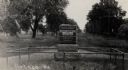
| Date: | 08 1959 |
|---|---|
| Description: | Visitors enjoy a stagecoach ride, an attraction at Old Wade House during the August "twilight tours" of this historic site. A team of two horses stand in t... |
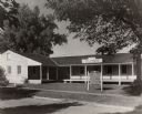
| Date: | 1920 |
|---|---|
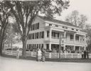
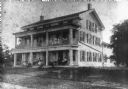
| Description: | View from road of the exterior of Wade House. Children and adults are posing sitting and standing on the porch and balcony. |
If you didn't find the material you searched for, our Library Reference Staff can help.
Call our reference desk at 608-264-6535 or email us at:

