 Filter: Categories of Wisconsin Historical Images
Filter: Subject of Historic sites
Filter: Creator Name of Unknown
Filter: Subject of human settlements
Filter: Categories of Wisconsin Historical Images
Filter: Subject of Historic sites
Filter: Creator Name of Unknown
Filter: Subject of human settlements
| Date: | |
|---|---|
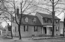
| Description: | View of the modest home of Mary Washington (1708-1789), purchased by George Washington in 1772. The two-story residence features a front porch and is situ... |
| Date: | |
|---|---|
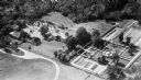
| Description: | Aerial view of Stratford Hall, the ancestral home of the family of Robert E. Lee, built in the Georgian style in 1725. To the right of the house, the kitc... |
| Date: | |
|---|---|
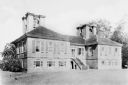
| Description: | Exterior view of Stratford Hall, the ancestral home of the family of Robert E. Lee, built in the Georgian style in 1725. The building features a central st... |
| Date: | |
|---|---|
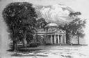
| Description: | Draswing of the exterior view of Monticello, built in 1769 by Thomas Jefferson. The residence features a colonnaded front porch and a central dome. |

| Date: | 1990 |
|---|---|
| Description: | A tourist map of Lafayette County, Wisconsin, that shows the locations of motels, camping, municipal parks, cheese factory tours, waysides, and golf course... |

| Date: | 1961 |
|---|---|
| Description: | This 1961 map of Ozaukee County, Wisconsin, identifies historic sites and landmarks in the county. Cities and villages, roads, and lakes and streams are al... |
| Date: | |
|---|---|
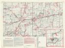
| Description: | This map shows the locations of historic sites and points of interest in Rusk County, Wisconsin. A location key, descriptions of the historical importance ... |

| Date: | 1960 |
|---|---|
| Description: | This mid-20th century tourist brochure for Bayfield County, Wisconsin, includes a map of the county showing towns, cities and villages, highways and roads,... |

| Date: | 1975 |
|---|---|
| Description: | This 1975 road map of Columbia County, Wisconsin, shows the location of historic sites in the county but lacks a key to those sites. It includes an inset m... |

| Date: | 1967 |
|---|---|
| Description: | This map of Cedarburg includes a list of historic buildings in the left margin. The map was created by the Ozaukee County Historical Society for Cedarburg'... |

| Date: | 1905 |
|---|---|
| Description: | Elevated view looking over Camp Randall to the University of Wisconsin campus taken from a home at 216 Campbell Street. Seen are Hiram Smith Hall, Dean Hen... |
| Date: | 1940 |
|---|---|
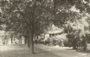
| Description: | A row of maple trees lines the brick walkway along the main house at Black Point. There are benches on the lawn; Geneva Lake is in the background. A gable ... |

| Date: | 1970 |
|---|---|
| Description: | This photocopy map shows the locations of historic buildings, as well as all other buildings in the isthmus. The map also includes photographs of selected ... |

| Date: | 11 01 1955 |
|---|---|
| Description: | Raymond Sivesind, director of the sites and markers program of the State Historical Society, as a speaker in the dedication and unveiling ceremony, stands ... |
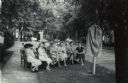
| Date: | 06 10 1955 |
|---|---|
| Description: | A small group is gathered for the dedication and unveiling of the First Church of Christ, Scientist historical marker in Oconto. Raymond Sivesind, supervis... |

| Date: | |
|---|---|
| Description: | Text on reverse reads: "Waelderhaus, the Girl Scout House of Kohler, Wisconsin, U.S.A. is characteristic of architecture in the Bregenzerwald, Vorariberg, ... |
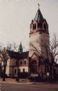
| Date: | |
|---|---|
| Description: | Color view of a church built in 1897 of local stone. Located at 9th and Main. National Historical Register. |

| Date: | 1937 |
|---|---|
| Description: | A view of the Quisling Towers Apartments, 1 E. Gilman Street, constructed for Abraham Quisling. The architectural style is called Streamline Moderne. In 19... |

| Date: | 1956 |
|---|---|
| Description: | The official site marker in front of the Wisconsin Historical Society Building. |
| Date: | 1967 |
|---|---|
| Description: | Text on reverse reads: "Solomon Juneau Homestead, Theresa, Wisconsin 53091. Solomon Juneau, a French trader, helped found Milwaukee and became its first Ma... |
If you didn't find the material you searched for, our Library Reference Staff can help.
Call our reference desk at 608-264-6535 or email us at: