 Filter: Categories of Wisconsin Historical Images
Filter: Subject of Hills
Filter: Subject of trees
Filter: Categories of Wisconsin Historical Images
Filter: Subject of Hills
Filter: Subject of trees

| Date: | 1910 |
|---|---|
| Description: | Exterior of ice cream parlor with a horse-drawn wagon parked on the right with sheds behind. Barrels are stacked on the porch. Signs above the porch read: ... |
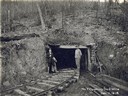
| Date: | 12 11 1918 |
|---|---|
| Description: | Two men, at least one of them a miner, standing in front of the no. 7 opening to the no. 2 mine. Benham was a "company town" created by International Harve... |
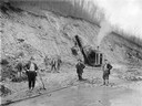
| Date: | 1919 |
|---|---|
| Description: | Workers standing outdoors in the mud with a steam shovel. Benham was a "company town" created by International Harvester for the workers of the Wisconsin S... |
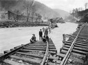
| Date: | 1919 |
|---|---|
| Description: | Men standing on the exposed portion of a flooded railroad track as a swiftly moving torrent of water is rushing past. Benham was a "company town" created b... |
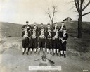
| Date: | 1915 |
|---|---|
| Description: | Group portrait of International Harvester's Milwaukee Works shop school baseball team. |
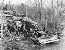
| Date: | 1944 |
|---|---|
| Description: | Royal Canadian Air Force men using an International TD-18 TracTracTor (crawler tractor) to salvage a B-34 bomber at Shell Camp Lake, Nova Scotia. |

| Date: | 1882 |
|---|---|
| Description: | Bird's-eye map of Lake Geneva, looking southwest, with insets of points of interest. |

| Date: | 1886 |
|---|---|
| Description: | Bird's-eye map of Menomonee Falls. |

| Date: | 1870 |
|---|---|
| Description: | Sauk City is the oldest incorporated village in Wisconsin (incorporated in 1854) and also has the oldest organized volunteer fire department in the state, ... |

| Date: | 1880 |
|---|---|
| Description: | Bird's-eye map of Waukesha, county seat of Waukesha County. |

| Date: | 1885 |
|---|---|
| Description: | Bird's-eye map of Waupun on the Rock River. There is an inset at top center of "Althouse, Wheeler & Co., Windmills and Pumps." |

| Date: | 1882 |
|---|---|
| Description: | This map of Cedarburg is a bird's-eye map with an inset of Cedarburg Brewery. Relief is shown pictorially and the map includes an index to buildings. |

| Date: | 1896 |
|---|---|
| Description: | Bird's-eye map of Darlington. Area bordered by Washington and North Streets, upper left hand corner, the fairgrounds, upper right corner, River Street, bot... |

| Date: | 1872 |
|---|---|
| Description: | Birds-eye drawing of Eau Claire depicts street names and street locations, houses, trees, bridges, piers, canals, railroads, and the Chippewa and Eau Clair... |

| Date: | 1880 |
|---|---|
| Description: | Bird's-eye map over the Mississippi River of Fountain City. Paddle steamers and steamboats are on the river, and bluffs are in the background. |

| Date: | 12 21 1882 |
|---|---|
| Description: | Bird's-eye map of Kaukauna, from the Appleton Post Annual Review. |

| Date: | 1879 |
|---|---|
| Description: | Bird's-eye map of Lake Mills. |
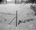
| Date: | 01 19 1945 |
|---|---|
| Description: | Stone bridge on Edgewood Drive, formerly an underpass for cows to access the lake. There are buildings further up the hill in the background. |
If you didn't find the material you searched for, our Library Reference Staff can help.
Call our reference desk at 608-264-6535 or email us at:

