 Filter: Categories of Wisconsin Historical Images
Filter: Subject of Hiking
Filter: Subject of transportation
Filter: Categories of Wisconsin Historical Images
Filter: Subject of Hiking
Filter: Subject of transportation

| Date: | 1994 |
|---|---|
| Description: | This brochure consists of a series of 16 maps of the Elroy-Sparta State Trail and the 400 State Trail, as well as the Omaha Trail between Sparta and Camp D... |
| Date: | |
|---|---|
| Description: | A group of men and women walking on an unpaved path through a forest area. |

| Date: | 1964 |
|---|---|
| Description: | This 1964 maps shows roads, boat landings and marinas, campgrounds, canoe trails and portages, and lakes and streams in parts of Vilas, Oneida, and Iron co... |
| Date: | |
|---|---|
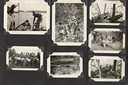
| Description: | Page from Joy Camps photo album displaying seven photographs. Scenes depicted: canoes and campers on a lake; campers on a wooden footbridge; campers cookin... |

| Date: | 1949 |
|---|---|
| Description: | This map shows points of interest, historic sites, buildings, trails, roads, and general animal and plant locations. |

| Date: | 1930 |
|---|---|
| Description: | This map shows roads and lakes and includes an inset illustration of Manitowish Waters Fish Hatchery. The back of the map includes a resorts directory, tex... |

| Date: | 1970 |
|---|---|
| Description: | This colored map displays a brief description of tourist attractions in the state, as well as a grid of state parks and recreational facilities. There is a... |

| Date: | 1966 |
|---|---|
| Description: | This colored road map shows automobile roads in Wisconsin as well as portions of nearby states. Information on the quality and type of any road shown (inte... |

| Date: | 1962 |
|---|---|
| Description: | This colored map represents "Tour #2" of a series of driving tours of the state published by the Sperry & Hutchinson Company, in order to "help you enjoy W... |

| Date: | 1962 |
|---|---|
| Description: | This colored map represents "Tour #1" of a series of driving tours of the state published by the Sperry & Hutchinson Company, in order to "help you enjoy W... |

| Date: | 1949 |
|---|---|
| Description: | This multi-colored promotional map for recreational activities in the Hayward area includes a graphic of distances from Midwestern cities to Hayward, with ... |
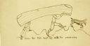
| Date: | 1910 |
|---|---|
| Description: | A humorous drawing by Carl of himself and another of The Gang carrying the folding canoe known as The Tub. They are depicted walking on uneven terrain ,wit... |
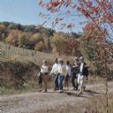
| Date: | 1967 |
|---|---|
| Description: | A group of men and women walking along a gravel path. |

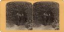
| Date: | 1911 |
|---|---|
| Description: | View down trail towards a small group of women and girls hiking in Cathedral Woods on a sunny day. The old growth forest is made up of pines and hemlocks. |

| Date: | 1960 |
|---|---|
| Description: | A man is running his dog on a trail in an old lead mining area. The trees are bare and fallen leaves are covering the ground. |
If you didn't find the material you searched for, our Library Reference Staff can help.
Call our reference desk at 608-264-6535 or email us at:
