 Filter: Categories of Wisconsin Historical Images
Filter: Subject of Hats
Filter: Subject of ocean
Filter: Subject of political science
Filter: Categories of Wisconsin Historical Images
Filter: Subject of Hats
Filter: Subject of ocean
Filter: Subject of political science

| Date: | 1893 |
|---|---|
| Description: | Front and back covers of an advertising brochure for the New Empire line of mowers, reapers and grain binders manufactured by J.F. Seiberling & Company. Th... |

| Date: | 1945 |
|---|---|
| Description: | Marines use an International TD-9 crawler tractor (TracTracTor) with a dozer shovel loader to fill a truck parked on a beach. A ship is in the water behind... |

| Date: | 1860 |
|---|---|
| Description: | Jefferson Davis and six sailors sail in a tea cup. A pirate flag flies overhead. One sailor is in the "crow's nest." Another is using a paddle. Three sailo... |
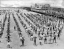
| Date: | 1920 |
|---|---|
| Description: | Elevated view of men, women and children standing in long rows along the beach, with fingers touching their shoulders, caught in the middle of an exercise ... |

| Date: | |
|---|---|
| Description: | Crowds walk along the boardwalk at Funchase amusement pier. A building with flags flying from its turrets features a sign that reads "Funchase Skating". T... |
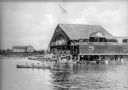
| Date: | 1920 |
|---|---|
| Description: | View across water toward a crowd of people standing on both the upper and lower level floors of a boathouse overlooking the lake. On the water beside the s... |
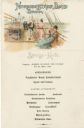
| Date: | 03 21 1901 |
|---|---|
| Description: | Supper menu from the S.S. Kaiser Wilhelm der Grosse of the Norddeutscher Lloyd shipping company, Bremen, with an illustration of people on the top d... |

| Date: | 1740 |
|---|---|
| Description: | Engraved and hand-colored map of the Iberian peninsula as a theater of war during the War of the Spanish Succession (1701-1714). The map is dedicated to Ki... |

| Date: | 1770 |
|---|---|
| Description: | Map of North America from the Great Lakes to the northern portion of South America. It shows cities, Native American land, mountains, swamps, lakes, rivers... |
If you didn't find the material you searched for, our Library Reference Staff can help.
Call our reference desk at 608-264-6535 or email us at: