 Filter: Categories of Wisconsin Historical Images
Filter: Subject of Hats
Filter: Subject of ocean
Filter: Subject of cities and towns
Filter: Categories of Wisconsin Historical Images
Filter: Subject of Hats
Filter: Subject of ocean
Filter: Subject of cities and towns
| Date: | |
|---|---|
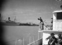
| Description: | Bloch on a ship in Mississippi at New Orleans, headed for Baton Rouge. Trip was gratis from Victor Ehr, director of the Baton Rouge chamber of commerce and... |
| Date: | |
|---|---|
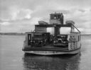
| Description: | View of an automobile ferry boat traveling to or from Shelter Island Heights. Several men are on the ferry, along with three automobiles. "Shelter Island O... |
| Date: | |
|---|---|
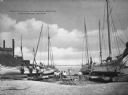
| Description: | View of a group of people posed near several oyster boats under repair on the shore. Some buildings are on the left side. A sign on the boat on the far rig... |

| Date: | 1968 |
|---|---|
| Description: | A man walking with a cane in the sand dunes on Coney Island. A dilapidated fence cuts across the foreground of the beach and a rock jetty juts into the ba... |
| Date: | 1920 |
|---|---|
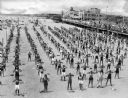
| Description: | Elevated view of men, women and children standing in long rows along the beach, with fingers touching their shoulders, caught in the middle of an exercise ... |
| Date: | 1920 |
|---|---|
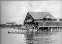
| Description: | View across water toward a crowd of people standing on both the upper and lower level floors of a boathouse overlooking the lake. On the water beside the s... |
| Date: | 1910 |
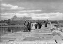
|---|---|
| Description: | A group of adults, mostly women, walk along the Rockland Breakwater. The Samoset Resort is in the background on the shoreline. Caption reads: "The Samoset ... |

| Date: | |
|---|---|
| Description: | Commercial postcard with slightly elevated view of people on the boardwalk at Atlantic City with the Traymore Hotel in the background. Postmarked from Atla... |

| Date: | 1676 |
|---|---|
| Description: | Detailed map of North and South America. Cities, towns, forests, and mountains are shown pictorially. Duval labels regions, islands, cities, lakes, and Nat... |

| Date: | 1684 |
|---|---|
| Description: | Map of North America showing some colonies, cities, rivers, lakes, and Native American land. Ship routes spread across both oceans, including one decorated... |

| Date: | 1770 |
|---|---|
| Description: | Map of North America from the Great Lakes to the northern portion of South America. It shows cities, Native American land, mountains, swamps, lakes, rivers... |

| Date: | 03 1913 |
|---|---|
| Description: | View across water towards a two-masted sailboat and a launch plying the waters of Havana Bay. Other boats are tied to the wharf in the background, with bui... |
If you didn't find the material you searched for, our Library Reference Staff can help.
Call our reference desk at 608-264-6535 or email us at: