 Filter: Categories of Wisconsin Historical Images
Filter: Subject of Hats
Filter: Subject of human settlements
Filter: Subject of islands
Filter: Categories of Wisconsin Historical Images
Filter: Subject of Hats
Filter: Subject of human settlements
Filter: Subject of islands

| Date: | |
|---|---|
| Description: | Elevated view from railing of immigrants boarding a ferry to depart Ellis Island. |
| Date: | |
|---|---|
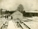
| Description: | Snow-covered buildings of a fishing village on Rock Island (also known as Pottawatomie Island). |
| Date: | 1910 |
|---|---|
| Description: | View from pier towards the Old Mission in La Pointe on Madeline Island. Men are sitting at the shoreline. Caption reads: "Apostle Islands, Wis. Madeline Is... |
| Date: | 1929 |
|---|---|
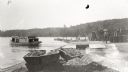
| Description: | One of the four harbors on Washington Island. There is a man on a pier or dock in the foreground, and a boat approaching on the left. A tree-lined shorelin... |

| Date: | 10 28 1938 |
|---|---|
| Description: | Man inspecting fish hung up to dry in a yard on Jones Island. |

| Date: | 1898 |
|---|---|
| Description: | View across road of Syl standing in front of a three-story duplex house on Jones Island. |
| Date: | 1931 |
|---|---|
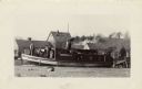
| Description: | The Frank Braeger is moored on the shore of Jones Island with steam issuing from the pipe, with the crew posing on the boat. In the background a man... |

| Date: | 1676 |
|---|---|
| Description: | Detailed map of North and South America. Cities, towns, forests, and mountains are shown pictorially. Duval labels regions, islands, cities, lakes, and Nat... |

| Date: | 1780 |
|---|---|
| Description: | Map of North and South America, showing the boundaries of colonial territories, cities, settlements, rivers, lakes, and Native American land. Particular em... |

| Date: | 1684 |
|---|---|
| Description: | Map of North America showing some colonies, cities, rivers, lakes, and Native American land. Ship routes spread across both oceans, including one decorated... |

| Date: | 1683 |
|---|---|
| Description: | Map of the north east coast of North America showing islands, regions, Native American land, bays, and a few European settlements. The Great Lakes appear i... |

| Date: | 1719 |
|---|---|
| Description: | Map of North America showing land divisions between France, Spain, England, Sweden, Denmark and Holland. The map is detailed, labeling cities, forts, islan... |

| Date: | 1770 |
|---|---|
| Description: | Map of North America from the Great Lakes to the northern portion of South America. It shows cities, Native American land, mountains, swamps, lakes, rivers... |
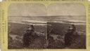
| Date: | |
|---|---|
| Description: | Stereograph of an elevated view of two men posing on Castle Rock. The Mississippi River is below with the city of Winona in the background, and hills are o... |

| Date: | 1939 |
|---|---|
| Description: | Advertising proof. Features an illustration of a man driving a truck in the Court of Pacifica. Below is Treasure Island and the hills of Berkeley. |
If you didn't find the material you searched for, our Library Reference Staff can help.
Call our reference desk at 608-264-6535 or email us at: