Filter: Categories of Wisconsin Historical Images
Filter: Subject of Hats
Filter: Subject of engraving
Filter: Subject of ships
Filter: Categories of Wisconsin Historical Images
Filter: Subject of Hats
Filter: Subject of engraving
Filter: Subject of ships
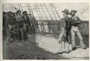
| Date: | 04 1884 |
|---|---|
| Description: | An engraving depicting the impressment of American seamen by the British Navy during the period before the War of 1812. The image shows a group of American... |

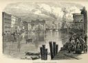
| Date: | 1873 |
|---|---|
| Description: | Engraved image of a lock and dam at Sault St. Marie. Two men are operating the sluice as ships are waiting on the opposite side of the lock. Another man is... |

| Date: | 1684 |
|---|---|
| Description: | Map of North America showing some colonies, cities, rivers, lakes, and Native American land. Ship routes spread across both oceans, including one decorated... |

| Date: | 1770 |
|---|---|
| Description: | Map of North America from the Great Lakes to the northern portion of South America. It shows cities, Native American land, mountains, swamps, lakes, rivers... |

| Date: | 1759 |
|---|---|
| Description: | Map of north eastern Canada and parts of New England, showing settlements, cities, portages, Native American land, mountains, lakes, and rivers. The unusua... |
If you didn't find the material you searched for, our Library Reference Staff can help.
Call our reference desk at 608-264-6535 or email us at: