 Filter: Categories of Wisconsin Historical Images
Filter: Subject of Hats
Filter: Subject of coasts
Filter: Categories of Wisconsin Historical Images
Filter: Subject of Hats
Filter: Subject of coasts
| Date: | |
|---|---|
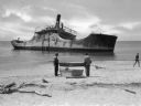
| Description: | View from shoreline toward the wreck of the S.S. Atlantus, a concrete hulled ship in the water near a shoreline. In the foreground are three men on ... |
| Date: | |
|---|---|
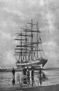
| Description: | A bark, the "Galena," stranded on Clatsop Beach, with three men and two women on the beach in the foreground. |
| Date: | |
|---|---|
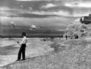
| Description: | View of men surf fishing along a rocky shoreline at Point State Park. |
| Date: | |
|---|---|
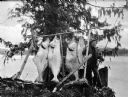
| Description: | A fishermen smoking a pipe poses with fish strung from a wooden pole beneath an evergreen tree. |
| Date: | |
|---|---|
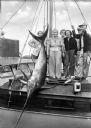
| Description: | Fishermen and women pose with a swordfish tied to a mast aboard a boat. |

| Date: | |
|---|---|
| Description: | People stand and sit on a driftwood-cluttered beach. Several people swim in the ocean. Caption reads: "Scene on the Beach. Long Beach. Wash." |
| Date: | 1945 |
|---|---|
| Description: | Leota Kelly, directer of the Pacific Athletic Club, division of the Red Cross, and colleagues, at the site of the new Red Cross Club in Tinian near a cliff... |

| Date: | 1968 |
|---|---|
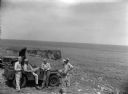
| Description: | Three-quarter view from front of passenger side of red International Scout with white Traveltop. Two people are in the front seat. The sides of the Travelt... |

| Date: | 1910 |
|---|---|
| Description: | View of Table Mountain and beach from Milnerton, South Africa. People are walking on the beach. |

| Date: | 1759 |
|---|---|
| Description: | Map of north eastern Canada and parts of New England, showing settlements, cities, portages, Native American land, mountains, lakes, and rivers. The unusua... |

| Date: | 1667 |
|---|---|
| Description: | Map of Virginia depicting the discoveries detailed by John Smith in his exploration of the region. It shows Jamestown, Native American tribes and villages,... |

| Date: | 07 02 1920 |
|---|---|
| Description: | Alfred Holt is standing on the beach, carrying several boxes under his arm. To his right is his father W.A. Holt. A group of eight women are sitting on the... |
If you didn't find the material you searched for, our Library Reference Staff can help.
Call our reference desk at 608-264-6535 or email us at: