 Filter: Categories of Wisconsin Historical Images
Filter: Subject of Harbors
Filter: Year of 1800-1899
Filter: Year of 1870-1879
Filter: Categories of Wisconsin Historical Images
Filter: Subject of Harbors
Filter: Year of 1800-1899
Filter: Year of 1870-1879

| Date: | 1873 |
|---|---|
| Description: | The harbor, showing the sidewheel packet, "Belle of La Crosse," and the sidewheel ferry "Alex McGregor." Other boats are also seen including two barges loa... |

| Date: | 1870 |
|---|---|
| Description: | Bird's-eye view of the city of Manitowoc with a population of 5,168 inhabitants as it appears in 1870, the year the village was granted a city charter by t... |
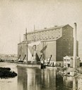
| Date: | 1870 |
|---|---|
| Description: | The Milwaukee & St. Paul Railway Company grain elevator at the Milwaukee harbor, with a sailing ship anchored nearby. |

| Date: | 1875 |
|---|---|
| Description: | The harbor piers and the entrance to the Sturgeon Bay ship canal. Men are standing on the shoreline. |

| Date: | 1876 |
|---|---|
| Description: | Made from U.S. Surveys and from minutes furnished by Jos. S. Buck and Dr. C. Chase. Scale 20 CHs to an inch. |
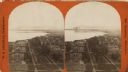
| Date: | 1876 |
|---|---|
| Description: | Stereograph. Elevated view looking roughly south, the foreground overlooks a residential neighborhood. On the far shoreline, smoke clouds spew out from lar... |

| Date: | 1874 |
|---|---|
| Description: | Engraved view of downtown Racine seen from Lake Michigan. Several vessels are entering the harbor, and a pier with a beacon is on the right. |

| Date: | 1876 |
|---|---|
| Description: | This 1876 map shows the mouth of the Ahnapee River at Algoma, Kewaunee County, Wisconsin, with soundings given in tenths of a foot. Proposed improvements a... |

| Date: | 1871 |
|---|---|
| Description: | Asaph Whittlesey arrived in Ashland in 1854, one of the earliest of the settlers who hoped the area would grow and make their fortunes. He drew this map of... |

| Date: | 1871 |
|---|---|
| Description: | Engraved view of Kenosha harbor. A group of men fish from a pier in the foreground while several boats float through the harbor. A tug is pulling a large s... |

| Date: | 1871 |
|---|---|
| Description: | Asaph Whittlesey arrived in Ashland in 1854, one of the earliest of the settlers who hoped the area would grow and make their fortunes. He drew this map of... |

| Date: | 1875 |
|---|---|
| Description: | This map oriented with the north to the upper left is ink, mounted on clothe. The depths of the water are shown by soundings. A handwritten inscription on ... |

| Date: | 1876 |
|---|---|
| Description: | This map shows existing and proposed harbor improvements, streets, the Sauk River, and Lake Michigan. On the bottom of the map inscribed in ink is: "44th C... |

| Date: | 1874 |
|---|---|
| Description: | This map shows piers, streets, the Manitowoc River and shore lines of 1856, 1869, 1873 and 1874. The top margin reads; "Soundings taken 1974." Written in i... |
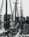
| Date: | 1875 |
|---|---|
| Description: | Elevated view of a deck of a schooner hauling lumber. Several workmen are loading or unloading the lumber. Industrial buildings, some displaying signs, are... |

| Date: | 1873 |
|---|---|
| Description: | This blueprint map shows water depths by soundings and isolines. To the top left is Duluth, Minnesota. To the bottom right is Superior City, Wisconsin. The... |
If you didn't find the material you searched for, our Library Reference Staff can help.
Call our reference desk at 608-264-6535 or email us at: