 Filter: Categories of Wisconsin Historical Images
Filter: Subject of Harbors
Filter: Year of 1800-1899
Filter: Subject of streets
Filter: Categories of Wisconsin Historical Images
Filter: Subject of Harbors
Filter: Year of 1800-1899
Filter: Subject of streets

| Date: | 1892 |
|---|---|
| Description: | Bird's-eye view of Chicago, with ships in the Lake Michigan harbor. |

| Date: | 1857 |
|---|---|
| Description: | This map of Sheboygan Harbor shows the river mouth and harbor, piers, wharfs, piles of old destroyed bridge wharfs, streets, and the lake shore from survey... |

| Date: | 1848 |
|---|---|
| Description: | Pen-and-ink on paper. The title of the map is inscribed on the back. The map shows buildings, roads, marshes, wild rice, piles and docks, deep water, and o... |

| Date: | 1876 |
|---|---|
| Description: | This map shows existing and proposed harbor improvements, streets, the Sauk River, and Lake Michigan. On the bottom of the map inscribed in ink is: "44th C... |

| Date: | 1857 |
|---|---|
| Description: | This map was created from a survey made in December 1855 and shows local streets, proposed roads, railroads, the lake shore, bridge wharfs, the basin, the ... |

| Date: | 1898 |
|---|---|
| Description: | This map shows blocks, industrial buildings, and railroads in portions of Duluth and Superior, as well as harbor lines, areas improved, and proposed improv... |

| Date: | 06 30 1893 |
|---|---|
| Description: | This map shows selected industrial buildings, streets, railroads, docks, and beacons in West Duluth, Duluth, West Superior, and Superior, as well as the St... |

| Date: | 1867 |
|---|---|
| Description: | This map shows components of the bottom of Lake Michigan and the Root River, as well as the harbor, buildings, streets, railroads, and rural landowners in ... |

| Date: | 09 1853 |
|---|---|
| Description: | This map shows streets, docks, warehouses, and piers near the harbor. The Manitowoc River and Lake Michigan are labeled. Depths are indicated by soundings ... |

| Date: | 1854 |
|---|---|
| Description: | This map shows streets, docks, warehouses, and piers near the harbor. Relief is shown by hachures and depths are shown by soundings and isolines. Lake Mich... |

| Date: | 1856 |
|---|---|
| Description: | This map shows streets, piers, and wharves. Lake Michigan, the Manitowoc River, and select buildings are labeled. Relief is shown by hachures and sounding... |

| Date: | 1874 |
|---|---|
| Description: | This map shows piers, streets, the Manitowoc River and shore lines of 1856, 1869, 1873 and 1874. The top margin reads; "Soundings taken 1974." Written in i... |

| Date: | 1857 |
|---|---|
| Description: | This map shows piers, wharves, streets, and the lake shore from the survey of August 1856. Lake Michigan and the Sheboygan River are labeled. Depths are sh... |
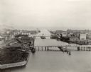
| Date: | 1898 |
|---|---|
| Description: | Bird's-eye view of the Manitowoc Harbor facing east from Northern Grain Company's Elevator B. In the foreground, Mathews & Keith's pile driver scow is secu... |
If you didn't find the material you searched for, our Library Reference Staff can help.
Call our reference desk at 608-264-6535 or email us at: